User:Jcreer/SMS:GSSHA Model Control: Difference between revisions
From XMS Wiki
Jump to navigationJump to search
| (57 intermediate revisions by 2 users not shown) | |||
| Line 1: | Line 1: | ||
__NOINDEX__ | __NOINDEX__ | ||
{{Version SMS 13.4}} | {{Version SMS 13.4}} | ||
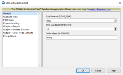
[[File:SMS GSSHA MC General.png|thumb|400 px|''GSSHA Model Control'' dialog showing ''General'' options]] | |||
==General== | ==General== | ||
*''Total time (TOT_TIME)'' – | *''Total time (TOT_TIME)'' – Enter an integer giving the total duration of the simulation in minutes | ||
*''Time step (TIMESTEP)'' – | *''Time step (TIMESTEP)'' – Enter an integer giving the duration of each time step in the simulation in seconds. The time step must be evenly divisible into 60 seconds (e.g., 1, 2, 3, 4, 5, 6, 10, 12, 15, 20, 30, or 60 seconds). | ||
*''Outlet slope (OUTSLOPE)'' – | *''Outlet slope (OUTSLOPE)'' – Enter an integer for the slope of the cell containing the watershed outlet. This must be a positive decimal number. | ||
==Overland Flow== | ==Overland Flow== | ||
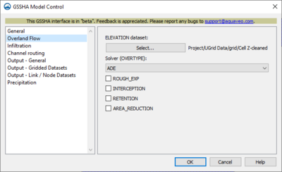
*''ELEVATION dataset'' – | [[File:SMS GSSHA MC Overland.png|thumb|400 px|''GSSHA Model Control'' dialog showing ''Overland Flow'' options]] | ||
**'''Select''' – | *''ELEVATION dataset'' – Here one chooses the dataset and enters the parameters to apply. | ||
*''Solver(OVERTYPE)'' – | **'''Select''' – Opens ''Select dataset for ELEVATION dataset'' dialog. Must specify one for use in model. | ||
**"ADE" | *''Solver(OVERTYPE)'' – Select one of the two following options from dropdown. Check any of the four following options if applicable. | ||
**"ADE-PC" | **"ADE" – Select this option when needing to use the Alternating Direction Explicit method. | ||
*'' | **"ADE-PC" – Select this option when needing to use the Alternating Direction Explicit Predictor-Corrector method. Completes most slowly, but is the most robust. | ||
*''INTERCEPTION'' – | *''ROUGH_EXP'' – Enter value to specify the roughness exponent for the ''Roughness Mapping Table''. | ||
*''RETENTION'' – | *''INTERCEPTION'' – If selected, will use data present in the ''Mapping Table'' file that shows amount of water abstracted by vegetation. | ||
*''AREA_REDUCTION'' – | *''RETENTION'' – Selecting this specifies that a uniform retention depth is to be used for all overland flow cells. | ||
*''AREA_REDUCTION'' – Selecting this reduces the area over which infiltration occurs (an impervious area fraction) | |||
{{-}} | |||
==Infiltration== | ==Infiltration== | ||
* ''Infiltration type'' – | [[File:SMS GSSHA MC Infiltration.png|thumb|400 px|''GSSHA Model Control'' dialog showing ''Infiltration'' options]] | ||
**"No infiltration" – | * ''Infiltration type'' – Select the method for calculating infiltration type from the drop down menu. | ||
**"Green & Ampt w/ soil moisture redistribution (INF_REDIST)" – | **"No infiltration" – Select in order to not calculate any infiltration. | ||
***''Soil moisture depth (SOIL_MOIST_DEPTH)'' – | **"Green & Ampt w/ soil moisture redistribution (INF_REDIST)" – Specifies infiltration calculations using ''Green and Ampt with Redistribution'' method - redistributes soil moisture during periods of no- or low- intensity rainfall | ||
***''Top layer depth (TOP_LAYER_DEPTH)'' – | ***''Soil moisture depth (SOIL_MOIST_DEPTH)'' – This specifies the total depth of the soil column over which evapotranspiration is distributed. | ||
**"Green & Ampt multilayer (INF_LAYERED_SOIL)" – | ***''Top layer depth (TOP_LAYER_DEPTH)'' – Selecting this allows input in meters of the depth that is less than or equal to the soil moisture depth. Default is equal to soil moisture depth. | ||
***''Soil moisture depth (SOIL_MOIST_DEPTH)'' – | **"Green & Ampt multilayer (INF_LAYERED_SOIL)" – Specifies three layered Green and Ampt infiltration | ||
**" | ***''Soil moisture depth (SOIL_MOIST_DEPTH)'' – This specifies the total depth of the soil column over which evapotranspiration is distributed. | ||
***''Weight (RICHARDS_WEIGHT)'' – | **"Richards' infiltration (INF_RICHARDS)" – Select when using Richards' equation to simulate infiltration. | ||
***''DTHETA MAx (RICHARDS_DTHETA_MAX)'' – | ***''Weight (RICHARDS_WEIGHT)'' – Used to determine how much weight is placed on upper and lower cells using the arithmetic weighting method for calculating inter-cell hydraulic conductivities. | ||
***''C option (RICHARDS_C_OPTION)'' – | ***''DTHETA MAx (RICHARDS_DTHETA_MAX)'' – Specifies maximum water content change allowable. Default value = 0.025. | ||
***''K option (RICHARDS_K_OPTION)'' – | ***''C option (RICHARDS_C_OPTION)'' – Hydraulic conductivity and water capacity values dependent on water content of each cell. Select either ''brooks'' or ''havercamp'' | ||
***''Upper option (RICHARDS_UPPER_OPTION)'' – | ***''K option (RICHARDS_K_OPTION)'' – Inter-cell hydraulic conductivity weighting method - ''ARITHMETIC'' or ''GEOMETRIC'' | ||
***''Max Iteration (RICHARDS_ITER_MAX)'' – | ***''Upper option (RICHARDS_UPPER_OPTION)'' – Selections here compute the hydraulic conductivity at the ground surface - either ''green_ampt'' or ''average'' | ||
***''Max num. cells (MAX_NUMBER_CELLS)'' – | ***''Max Iteration (RICHARDS_ITER_MAX)'' – Maximum number of iterations specified by the user. Default = 1. | ||
***''Soil moisture depth (SOIL_MOIST_DEPTH)'' – | ***''Max num. cells (MAX_NUMBER_CELLS)'' – This is an integer value which is the maximum number of cells in any unsaturated soil column. | ||
***''Soil moisture depth (SOIL_MOIST_DEPTH)'' – This specifies the maximum depth for distributing potential evapotranspiration demand. | |||
==Channel Routing== | ==Channel Routing== | ||
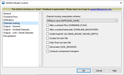
[[File:SMS GSSHA MC ChannelRouting.png|thumb|400 px|''GSSHA Model Control'' dialog showing ''Channel Routing'' options]] | |||
*''Channel routing computation scheme'' – Select either ''No routing'' or ''Diffusive wave (DIFFUSIVE_WAVE)''. | |||
*''No routing'' – If this option is chosen, no calculations are done to specify the water routing. | |||
*''Diffusive wave (DIFFUSIVE_WAVE)'' – Selecting this specifies explicit diffusive-wave 1-D channel routing. | |||
**''Allow overbank flow (OVERBANK_FLOW)'' – Selecting this allows the water in the channel to flow back onto the overflow plane when the stream elevation is above the top of the bank. | |||
**''Allow overland backwater (OVERLAND_BACKWATER)'' – Selecting this option includes backwater effects on the overland when the stream water surface elevation or TOB is greater than overland flow surface elevation without allowing water in the channel to flow back onto the overland. | |||
**''Outlet head BC (HEAD_BOUND / BOUND_DEPTH)'' – Enter a decimal value for the specified head boundary at the channel outlet. | |||
**''Create hot start file'' – Check box to save a file containing soil moistures for every grid cell in the watershed after the simulation has run. | |||
**''Start from hot start file'' – Check box in order to select a file containing starting surface moisture data for every grid cell in the watershed | |||
**''Soil erosion (SOIL_EROSION)'' – Allows user to calculate overland soil erosion. | |||
***''Sediment porosity (SED_POROSITY)'' – Enter the value of the porosity of the channel bed sediments. This value must be between 0.0 and 1.0. The default is 0.25. | |||
***''Water temperature (WATER_TEMP)'' – Enter the value of the water temperature | |||
***''Sand size (SAND_SIZE)'' – Enter the value of the representative grain-size of the sand. | |||
**''Compute containment transport'' – Checking this allows entry of integers to calculate the containment transport. | |||
***''Decay coefficient (per day) (CHAN_DECAY_COEF)'' – Enter the decay value per day. Default is 0.0. | |||
***''Dispersion coefficient (m^2/s) (CHAN_DISP_COEF)'' – Enter the channel dispersion coefficient. Default is 0.0. | |||
***''Initial concentration (mg/l) (INIT_CHAN_CONC)'' – Enter the initial contamination concentrations. | |||
==Output – General== | ==Output – General== | ||
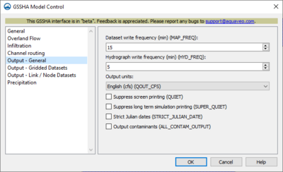
[[File:SMS GSSHA MC Output General.png|thumb|400 px|''GSSHA Model Control'' dialog showing ''Output – General'' options]] | |||
*''Dataset write frequency (MAP_FREQ)'' – Enter an integer representing the frequency in minutes that the output maps are written to. Required only if output maps are specified. | |||
*''Hydrograph write frequency (HYD_FREQ)'' – Enter an integer in minutes for the frequency the node dataset output is written to. | |||
*''Output units'' – Select the type of output unit needed for your results from the dropdown menu. | |||
**"English (QOUT_CFS)" – Select this option to show outflow hydrograph ordinates in ft<sup>3</sup>/s. | |||
**"Meters (METRIC)" – Select this option to show the outflow hydrograph ordinates in m<sup>3</sup>/s. | |||
*''Suppress screen printing (QUIET)'' – Selecting this option suppresses printing information to the screen each time step. | |||
*''Suppress long term simulation printing (SUPER_QUIET)'' – Selecting this option suppresses all printing of information to the screen. Useful in calibration mode. | |||
*''Strict Julian dates (STRICT_JULIAN_DATE)'' – Selecting this option makes all time series data output with strict Julian dates. | |||
*''Output contaminants (ALL_CONTAM_OUTPUT)'' – Selecting this option specifies that all contaminant information is output for every cell, node, time step, and hydrograph frequency. Maps and tables for each type of contaminant for each time step and node will be created. Creates enormous amounts of information. | |||
{{-}} | |||
==Output – Gridded Datasets== | ==Output – Gridded Datasets== | ||
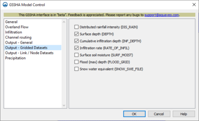
[[File:SMS GSSHA MC Gridded Datasets.png|thumb|400 px|''GSSHA Model Control'' dialog showing ''Output – Gridded Datasets'' options]] | |||
*''Distributed rainfall intensity (DIS_RAIN)'' – Selecting this creates maps showing the rainfall rate as it is being applied | |||
*''Surface depth (DEPTH)'' – Selecting this option creates an output filename to show maps of overland flow depth at set time steps. | |||
*''Cumulative infiltration depth (INF_DEPTH)'' – Selecting this creates an output file name to show maps of the cumulative infiltrated depth every time step | |||
*''Infiltration rate (RATE_OF_INFIL)'' – Selecting this option creates an output filename to show the map of infiltration rates for every time step. | |||
*''Surface soil moisture (SURF_MOIST)'' – soil volumetric water content | |||
*''Flood (max) depth (FLOOD_GRID)'' – This outputs the maximum water depth on the overland grid. | |||
*''Snow water equivalent (SNOW_SWE_FILE)'' – Selecting this creates a time series snow water equivalent maps. | |||
{{-}} | |||
==Output – Link/Node Datasets== | ==Output – Link/Node Datasets== | ||
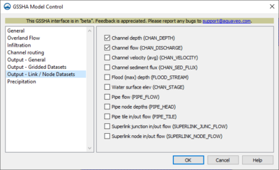
[[File:SMS GSSHA MC Output Link-Node.png|thumb|400 px|''GSSHA Model Control'' dialog showing ''Output – Link/Node Datasets'' options]] | |||
*''Channel depth (CHAN_DEPTH)'' – Select this to create a file for output of link/node datasets of channel depth for every time step specified | |||
*''Channel flow (CHAN_DISCHARGE)'' – Select this to create maps for every time step specified. Requires ''DIFFUSIVE_WAVE''. | |||
*''Channel velocity (avg) (CHAN_VELOCITY)'' – Selecting this creates a file to output the link/node data of the channel velocity for every time step specified. | |||
*''Channel sediment flux (CHAN_SED_FLUX)'' – Selecting this creates a file to output the sediment flux within the channel for the time steps specified. | |||
*''Flood (max) depth (FLOOD_STREAM)'' – Selecting this creates a file to output the maximum water depth on the stream network. | |||
*''Water surface elev (CHAN_STAGE)'' – Selecting this creates a file to output link/node data of channel stages at every specified time step. | |||
*''Pipe flow (PIPE_FLOW)'' – Selecting this creates a file to output pipe flow data. | |||
*''Pipe node depths (PIPE_HEAD)'' – Selecting this creates a file to output pipe node depths data. | |||
*''Pipe tile in/out flow (PIPE_TILE)'' – Selecting this creates a file to output pipe tile in/out flow data. | |||
*''Superlink junction in/out flow (SUPERLINK_JUNC_FLOW)'' – Select to access the file containing the time series output data for junctions | |||
*''Superlink node in/out flow (SUPERLINK_NODE_FLOW)'' – Select to access the file containing the time series output data for the nodes | |||
{{-}} | |||
==Precipitation== | ==Precipitation== | ||
[[File:SMS GSSHA MC Precipitation.png|thumb|400 px|''GSSHA Model Control'' dialog showing ''Precipitation'' options]] | |||
*''Precipitation type:'' – Select one of the two methods for simulation | |||
**''Uniform (PRECIP_UNIF)'' – Select this for uniform rainfall in both time and over every cell of the grid. | |||
***''Start date/time (START_DATE,START_TIME):'' – Edit the calendar start date and start time. | |||
***''Intensity (mm/hr) (RAIN_INTESITY):'' – Input how intense the rain is over the grid and during the simulation time. Uniform throughout. | |||
***''Duration (min) (RAIN_DURATION):'' – Input the length of time in minutes the rain is falling for the simulation | |||
**''Hyetograph'' – Selecting this creates a graph showing the types of precipitation over a specified time. | |||
***''Start date/time (START_DATE,START_TIME):'' – Enter the calendar date and the clock time specifying when to begin the simulation | |||
***''Hyetograph:'' – Filling in data in the following fields allows for the creation of the hyetograph. | |||
***'''Edit XY Series...''' – Clicking this button brings up the ''[[SMS:XY Series Editor| XY Series Editor]]'' dialog. | |||
***''Average depth (mm):'' – Enter the average depth of the rainfall in millimeters. | |||
{{Navbox SMS}} | |||
Latest revision as of 16:21, 17 May 2024
| This contains information about functionality available starting at SMS version 13.4. The content may not apply to other versions. |
General
- Total time (TOT_TIME) – Enter an integer giving the total duration of the simulation in minutes
- Time step (TIMESTEP) – Enter an integer giving the duration of each time step in the simulation in seconds. The time step must be evenly divisible into 60 seconds (e.g., 1, 2, 3, 4, 5, 6, 10, 12, 15, 20, 30, or 60 seconds).
- Outlet slope (OUTSLOPE) – Enter an integer for the slope of the cell containing the watershed outlet. This must be a positive decimal number.
Overland Flow
- ELEVATION dataset – Here one chooses the dataset and enters the parameters to apply.
- Select – Opens Select dataset for ELEVATION dataset dialog. Must specify one for use in model.
- Solver(OVERTYPE) – Select one of the two following options from dropdown. Check any of the four following options if applicable.
- "ADE" – Select this option when needing to use the Alternating Direction Explicit method.
- "ADE-PC" – Select this option when needing to use the Alternating Direction Explicit Predictor-Corrector method. Completes most slowly, but is the most robust.
- ROUGH_EXP – Enter value to specify the roughness exponent for the Roughness Mapping Table.
- INTERCEPTION – If selected, will use data present in the Mapping Table file that shows amount of water abstracted by vegetation.
- RETENTION – Selecting this specifies that a uniform retention depth is to be used for all overland flow cells.
- AREA_REDUCTION – Selecting this reduces the area over which infiltration occurs (an impervious area fraction)
Infiltration
- Infiltration type – Select the method for calculating infiltration type from the drop down menu.
- "No infiltration" – Select in order to not calculate any infiltration.
- "Green & Ampt w/ soil moisture redistribution (INF_REDIST)" – Specifies infiltration calculations using Green and Ampt with Redistribution method - redistributes soil moisture during periods of no- or low- intensity rainfall
- Soil moisture depth (SOIL_MOIST_DEPTH) – This specifies the total depth of the soil column over which evapotranspiration is distributed.
- Top layer depth (TOP_LAYER_DEPTH) – Selecting this allows input in meters of the depth that is less than or equal to the soil moisture depth. Default is equal to soil moisture depth.
- "Green & Ampt multilayer (INF_LAYERED_SOIL)" – Specifies three layered Green and Ampt infiltration
- Soil moisture depth (SOIL_MOIST_DEPTH) – This specifies the total depth of the soil column over which evapotranspiration is distributed.
- "Richards' infiltration (INF_RICHARDS)" – Select when using Richards' equation to simulate infiltration.
- Weight (RICHARDS_WEIGHT) – Used to determine how much weight is placed on upper and lower cells using the arithmetic weighting method for calculating inter-cell hydraulic conductivities.
- DTHETA MAx (RICHARDS_DTHETA_MAX) – Specifies maximum water content change allowable. Default value = 0.025.
- C option (RICHARDS_C_OPTION) – Hydraulic conductivity and water capacity values dependent on water content of each cell. Select either brooks or havercamp
- K option (RICHARDS_K_OPTION) – Inter-cell hydraulic conductivity weighting method - ARITHMETIC or GEOMETRIC
- Upper option (RICHARDS_UPPER_OPTION) – Selections here compute the hydraulic conductivity at the ground surface - either green_ampt or average
- Max Iteration (RICHARDS_ITER_MAX) – Maximum number of iterations specified by the user. Default = 1.
- Max num. cells (MAX_NUMBER_CELLS) – This is an integer value which is the maximum number of cells in any unsaturated soil column.
- Soil moisture depth (SOIL_MOIST_DEPTH) – This specifies the maximum depth for distributing potential evapotranspiration demand.
Channel Routing
- Channel routing computation scheme – Select either No routing or Diffusive wave (DIFFUSIVE_WAVE).
- No routing – If this option is chosen, no calculations are done to specify the water routing.
- Diffusive wave (DIFFUSIVE_WAVE) – Selecting this specifies explicit diffusive-wave 1-D channel routing.
- Allow overbank flow (OVERBANK_FLOW) – Selecting this allows the water in the channel to flow back onto the overflow plane when the stream elevation is above the top of the bank.
- Allow overland backwater (OVERLAND_BACKWATER) – Selecting this option includes backwater effects on the overland when the stream water surface elevation or TOB is greater than overland flow surface elevation without allowing water in the channel to flow back onto the overland.
- Outlet head BC (HEAD_BOUND / BOUND_DEPTH) – Enter a decimal value for the specified head boundary at the channel outlet.
- Create hot start file – Check box to save a file containing soil moistures for every grid cell in the watershed after the simulation has run.
- Start from hot start file – Check box in order to select a file containing starting surface moisture data for every grid cell in the watershed
- Soil erosion (SOIL_EROSION) – Allows user to calculate overland soil erosion.
- Sediment porosity (SED_POROSITY) – Enter the value of the porosity of the channel bed sediments. This value must be between 0.0 and 1.0. The default is 0.25.
- Water temperature (WATER_TEMP) – Enter the value of the water temperature
- Sand size (SAND_SIZE) – Enter the value of the representative grain-size of the sand.
- Compute containment transport – Checking this allows entry of integers to calculate the containment transport.
- Decay coefficient (per day) (CHAN_DECAY_COEF) – Enter the decay value per day. Default is 0.0.
- Dispersion coefficient (m^2/s) (CHAN_DISP_COEF) – Enter the channel dispersion coefficient. Default is 0.0.
- Initial concentration (mg/l) (INIT_CHAN_CONC) – Enter the initial contamination concentrations.
Output – General
- Dataset write frequency (MAP_FREQ) – Enter an integer representing the frequency in minutes that the output maps are written to. Required only if output maps are specified.
- Hydrograph write frequency (HYD_FREQ) – Enter an integer in minutes for the frequency the node dataset output is written to.
- Output units – Select the type of output unit needed for your results from the dropdown menu.
- "English (QOUT_CFS)" – Select this option to show outflow hydrograph ordinates in ft3/s.
- "Meters (METRIC)" – Select this option to show the outflow hydrograph ordinates in m3/s.
- Suppress screen printing (QUIET) – Selecting this option suppresses printing information to the screen each time step.
- Suppress long term simulation printing (SUPER_QUIET) – Selecting this option suppresses all printing of information to the screen. Useful in calibration mode.
- Strict Julian dates (STRICT_JULIAN_DATE) – Selecting this option makes all time series data output with strict Julian dates.
- Output contaminants (ALL_CONTAM_OUTPUT) – Selecting this option specifies that all contaminant information is output for every cell, node, time step, and hydrograph frequency. Maps and tables for each type of contaminant for each time step and node will be created. Creates enormous amounts of information.
Output – Gridded Datasets
- Distributed rainfall intensity (DIS_RAIN) – Selecting this creates maps showing the rainfall rate as it is being applied
- Surface depth (DEPTH) – Selecting this option creates an output filename to show maps of overland flow depth at set time steps.
- Cumulative infiltration depth (INF_DEPTH) – Selecting this creates an output file name to show maps of the cumulative infiltrated depth every time step
- Infiltration rate (RATE_OF_INFIL) – Selecting this option creates an output filename to show the map of infiltration rates for every time step.
- Surface soil moisture (SURF_MOIST) – soil volumetric water content
- Flood (max) depth (FLOOD_GRID) – This outputs the maximum water depth on the overland grid.
- Snow water equivalent (SNOW_SWE_FILE) – Selecting this creates a time series snow water equivalent maps.
Output – Link/Node Datasets
- Channel depth (CHAN_DEPTH) – Select this to create a file for output of link/node datasets of channel depth for every time step specified
- Channel flow (CHAN_DISCHARGE) – Select this to create maps for every time step specified. Requires DIFFUSIVE_WAVE.
- Channel velocity (avg) (CHAN_VELOCITY) – Selecting this creates a file to output the link/node data of the channel velocity for every time step specified.
- Channel sediment flux (CHAN_SED_FLUX) – Selecting this creates a file to output the sediment flux within the channel for the time steps specified.
- Flood (max) depth (FLOOD_STREAM) – Selecting this creates a file to output the maximum water depth on the stream network.
- Water surface elev (CHAN_STAGE) – Selecting this creates a file to output link/node data of channel stages at every specified time step.
- Pipe flow (PIPE_FLOW) – Selecting this creates a file to output pipe flow data.
- Pipe node depths (PIPE_HEAD) – Selecting this creates a file to output pipe node depths data.
- Pipe tile in/out flow (PIPE_TILE) – Selecting this creates a file to output pipe tile in/out flow data.
- Superlink junction in/out flow (SUPERLINK_JUNC_FLOW) – Select to access the file containing the time series output data for junctions
- Superlink node in/out flow (SUPERLINK_NODE_FLOW) – Select to access the file containing the time series output data for the nodes
Precipitation
- Precipitation type: – Select one of the two methods for simulation
- Uniform (PRECIP_UNIF) – Select this for uniform rainfall in both time and over every cell of the grid.
- Start date/time (START_DATE,START_TIME): – Edit the calendar start date and start time.
- Intensity (mm/hr) (RAIN_INTESITY): – Input how intense the rain is over the grid and during the simulation time. Uniform throughout.
- Duration (min) (RAIN_DURATION): – Input the length of time in minutes the rain is falling for the simulation
- Hyetograph – Selecting this creates a graph showing the types of precipitation over a specified time.
- Start date/time (START_DATE,START_TIME): – Enter the calendar date and the clock time specifying when to begin the simulation
- Hyetograph: – Filling in data in the following fields allows for the creation of the hyetograph.
- Edit XY Series... – Clicking this button brings up the XY Series Editor dialog.
- Average depth (mm): – Enter the average depth of the rainfall in millimeters.
- Uniform (PRECIP_UNIF) – Select this for uniform rainfall in both time and over every cell of the grid.
SMS – Surface-water Modeling System | ||
|---|---|---|
| Modules: | 1D Grid • Cartesian Grid • Curvilinear Grid • GIS • Map • Mesh • Particle • Quadtree • Raster • Scatter • UGrid |  |
| General Models: | 3D Structure • FVCOM • Generic • PTM | |
| Coastal Models: | ADCIRC • BOUSS-2D • CGWAVE • CMS-Flow • CMS-Wave • GenCade • STWAVE • WAM | |
| Riverine/Estuarine Models: | AdH • HEC-RAS • HYDRO AS-2D • RMA2 • RMA4 • SRH-2D • TUFLOW • TUFLOW FV | |
| Aquaveo • SMS Tutorials • SMS Workflows | ||
