User:Jcreer/SMS:SRH-2D Floodway Tools: Difference between revisions
From XMS Wiki
Jump to navigationJump to search
| Line 3: | Line 3: | ||
==Generate Floodway Simulation== | ==Generate Floodway Simulation== | ||
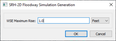
[[File:SRH-FloodwaySimulationGeneration.png|thumb|380 px|The ''SRH-2D Floodway Simulation Generation'' dialog]] | [[File:SRH-FloodwaySimulationGeneration.png|thumb|380 px|The ''SRH-2D Floodway Simulation Generation'' dialog]] | ||
The ''Generate Floodway Simulation'' tool creates a new SHR-2D simulation to evaluate a floodway. The tool is accessed using the SRH-2D simulation right-click menu selecting the ''Floodway Tools'' | '''Generate Floodway Simulations''' command. The tool will bring up the ''SRH-2D Floodway Simulation Generation'' dialog. The dialog has the following options: | |||
*''WSE Maximum Rise'' – The maximum rise for the water surface elevation in the floodway simulation. This value should be positive. | |||
*Units – Set the units for the WSE maximum rise. The units should match the project units. | |||
{{-}} | {{-}} | ||
Revision as of 21:54, 29 July 2021
Generate Floodway Simulation
The Generate Floodway Simulation tool creates a new SHR-2D simulation to evaluate a floodway. The tool is accessed using the SRH-2D simulation right-click menu selecting the Floodway Tools | Generate Floodway Simulations command. The tool will bring up the SRH-2D Floodway Simulation Generation dialog. The dialog has the following options:
- WSE Maximum Rise – The maximum rise for the water surface elevation in the floodway simulation. This value should be positive.
- Units – Set the units for the WSE maximum rise. The units should match the project units.
Generate Floodway Elevation Lines
Compare Floodway Simulation Data
Related Topics
SMS – Surface-water Modeling System | ||
|---|---|---|
| Modules: | 1D Grid • Cartesian Grid • Curvilinear Grid • GIS • Map • Mesh • Particle • Quadtree • Raster • Scatter • UGrid |  |
| General Models: | 3D Structure • FVCOM • Generic • PTM | |
| Coastal Models: | ADCIRC • BOUSS-2D • CGWAVE • CMS-Flow • CMS-Wave • GenCade • STWAVE • WAM | |
| Riverine/Estuarine Models: | AdH • HEC-RAS • HYDRO AS-2D • RMA2 • RMA4 • SRH-2D • TUFLOW • TUFLOW FV | |
| Aquaveo • SMS Tutorials • SMS Workflows | ||
