User:Jcreer/SMS:SRH-2D Summary Report: Difference between revisions
| Line 10: | Line 10: | ||
*''Model developer name'' – Enter the name of the person or organization that developed the model. | *''Model developer name'' – Enter the name of the person or organization that developed the model. | ||
*''Source of terrain data'' – Enter the source of the terrain data that is used in the project. | *''Source of terrain data'' – Enter the source of the terrain data that is used in the project. | ||
*''Source of bathymetry data'' | *''Source of bathymetry data'' – Enter the source of the bathymetry (depth or elevation) data that is used in the project. | ||
*''Source of additional survey data'' | *''Source of additional survey data'' | ||
*''Include all SRH-2D simulations'' | *''Include all SRH-2D simulations'' | ||
Revision as of 19:20, 2 July 2020
| This contains information about functionality available starting at SMS version 13.1. The content may not apply to other versions. |
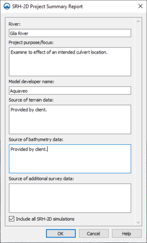
SMS allows creating report summary reports for SRH-2D. This is done by right-clicking on the SRH-2D simulation in the Project Explorer, then selecting the Summary Report command. THe SRH-2D Project Summary Report dialog will appear.
SRH-2D Project Summary Report Dialog
The SRH-2D Project Summary Report dialog has the following options:
- River – Enter the name of the river(s) or other waterway(s) being examined in the project.
- Project purpose/focus – Enter a description of the project purpose or focus.
- Model developer name – Enter the name of the person or organization that developed the model.
- Source of terrain data – Enter the source of the terrain data that is used in the project.
- Source of bathymetry data – Enter the source of the bathymetry (depth or elevation) data that is used in the project.
- Source of additional survey data
- Include all SRH-2D simulations
All options in the SRH-2D Project Summary Report dialog are optional. After clicking OK, the report summary files will be generated.
Summary Report Output Files
After clicking OK in the SRH-2D Summary Report dialog, the report files are generated. These files will be stored in the folder called "reports" that will be generated in the same directory as the project file. Inside the reports folder, the following files can be found:
- boundary condition plot
- structure boundary condition plot
- mesh plot
- mesh quality plot
- elevation plot
The files are saved out as HTML files and can be viewed using a web browser.
Related Topics
SMS – Surface-water Modeling System | ||
|---|---|---|
| Modules: | 1D Grid • Cartesian Grid • Curvilinear Grid • GIS • Map • Mesh • Particle • Quadtree • Raster • Scatter • UGrid |  |
| General Models: | 3D Structure • FVCOM • Generic • PTM | |
| Coastal Models: | ADCIRC • BOUSS-2D • CGWAVE • CMS-Flow • CMS-Wave • GenCade • STWAVE • WAM | |
| Riverine/Estuarine Models: | AdH • HEC-RAS • HYDRO AS-2D • RMA2 • RMA4 • SRH-2D • TUFLOW • TUFLOW FV | |
| Aquaveo • SMS Tutorials • SMS Workflows | ||
