GMS:3D Scatter Point Display Options
From XMS Wiki
(Redirected from GMS:3D Scatter Point Display Option)
Jump to navigationJump to search
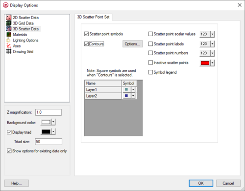
The properties of all 3D scatter data that GMS displays on the screen can be controlled through the 3D Scatter tab of the Display Options dialog. This dialog is opened by right-clicking on the 3D Scatter Data ![]() entry in the Project Explorer and selecting the Display Options command. It can also be accessed from the from the Display menu or the Display Options
entry in the Project Explorer and selecting the Display Options command. It can also be accessed from the from the Display menu or the Display Options ![]() macro. The following table describes the display options available for the 3D Scatter Point module.
macro. The following table describes the display options available for the 3D Scatter Point module.
| Display Option | Description |
|---|---|
| Scatter point symbols | Displays a symbol at the location of each scatter point. The symbol and color displayed for each dataset is adjusted in the table at the bottom left corner of the 3D Scatter Point Set tab. Clicking the box to the left of the dataset name opens a Symbol Attributes dialog for adjusting the size, color, and style of dataset points. As noted, when Contours is on, the point symbol is a square. Furthermore, the contour color settings override the settings determined in the symbols table. But the size of each point symbol is always determined by the Size option of the Symbol Attributes dialog. |
| Contours | Individual scatter points can be colored based on the current dataset using contour options. |
| Scatter point scalar values | Displays the value of the active dataset next to each of the scatter points. |
| Scatter point labels | Displays the scatter point label next to each scatter point. The scatter point label can be adjusted in the Properties dialog. To do so, select scatter points in the Graphics Window and use the Properties right-click menu command. |
| Scatter point numbers | Displays the scatter point ID next to each scatter point. |
| Inactive scatter points | Individual scatter points can either be active or inactive. The Inactive scatter points controls the display of the inactive points. |
| Symbol legend | Displays a symbol legend listing each of the scatter point sets by name and showing the symbol associated with the scatter point sets. |
GMS – Groundwater Modeling System | ||
|---|---|---|
| Modules: | 2D Grid • 2D Mesh • 2D Scatter Point • 3D Grid • 3D Mesh • 3D Scatter Point • Boreholes • GIS • Map • Solid • TINs • UGrids | |
| Models: | FEFLOW • FEMWATER • HydroGeoSphere • MODAEM • MODFLOW • MODPATH • mod-PATH3DU • MT3DMS • MT3D-USGS • PEST • PHT3D • RT3D • SEAM3D • SEAWAT • SEEP2D • T-PROGS • ZONEBUDGET | |
| Aquaveo | ||

