SMS:PTM Arc Attributes Dialog
From XMS Wiki
(Redirected from SMS:PTM Arc Attribute Dialog)
Jump to navigationJump to search
Feature arcs created in a PTM type coverage can be used to create either sources or traps.
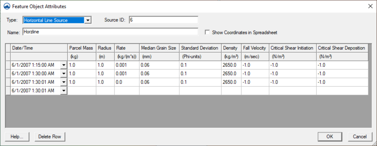
Feature Object Attributes dialog for a Source Arc
- Type – The selected option will determine which options are available. Options include; "Generic", "Horizontal Line Source", and "Horizontal Line Trap".
- Source ID – Used to give multiple source arcs differing IDs so that multiple sources can be tracked.
- Name – Field where a description for the source arc can be entered.
- Show Coordinates in Spreadsheet – Toggling on this option will populate the spreadsheet below with coordinate columns.
- Date/Time
- Parcel Mass – Each parcel represents a specific amount of sediment. Combined with the rate PTM computes the number of parcels being tracked. When a specific quantity of material is being generated by a dredge or other source, this amount allows the tracking of all of that material.
- Radius – PTM will distribute the parcels generated for this source randomly along the line. The position will also vary around the line within this specified radius.
- Rate – A specific quantity of sediment will be generated based on this rate. The longer the line, the more sediment is added to the flow field.
- Median Grain Size – This is the d50 of the sediment being added.
- Standard Deviation – This phi unit defines how the grain size varies from one parcel to the next.
- Density – This is the density of the sediment. This can be reduced to the density of water to create neutrally buoyant particles.
- Fall Velocity – This is the speed of descent of the particles. The shape of the particle influences this quantity. Entering a value of -1 tells PTM to compute this value.
- Critical Shear Intiation – Specifies the shear values to initialize motion for this particle.
- Critical Shear Deposition – The threshold for this particle to settle.
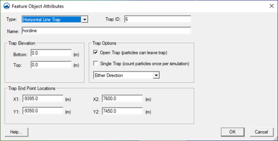
Feature Object Attributes dialog for a Trap Arc
- Type – The selected option will determine which options are available. Options include; "Generic", "Horizontal Line Source", and "Horizontal Line Trap".
- Trap ID – Used to give multiple trap arcs differing IDs so that multiple traps can be tracked.
- Name – Field where a description for the trap arc can be entered.
- Trap Elevation
- Bottom
- Top
- Trap Options
- Open Trap (particles can leave trap)
- Single Trap (Count particles once per simulation)
- Trap End Point Locations
- X1
- X2
- Y1
- Y2
Related Topics
SMS – Surface-water Modeling System | ||
|---|---|---|
| Modules: | 1D Grid • Cartesian Grid • Curvilinear Grid • GIS • Map • Mesh • Particle • Quadtree • Raster • Scatter • UGrid |  |
| General Models: | 3D Structure • FVCOM • Generic • PTM | |
| Coastal Models: | ADCIRC • BOUSS-2D • CGWAVE • CMS-Flow • CMS-Wave • GenCade • STWAVE • WAM | |
| Riverine/Estuarine Models: | AdH • HEC-RAS • HYDRO AS-2D • RMA2 • RMA4 • SRH-2D • TUFLOW • TUFLOW FV | |
| Aquaveo • SMS Tutorials • SMS Workflows | ||

