SMS:PTM Traps
From XMS Wiki
(Redirected from SMS:PTM Horizontal Line Trap)
Jump to navigationJump to search
A trap is defined as an area into which particles enter and are counted.
Global Trap Options
Global options affect all traps.
- Time limits can be specified on the trap's operation in the Time tab of the PTM Model Control dialog.
- Traps can be set to only be active on the last time step of the PTM simulation by selecting "Last timestep trap" in the Time tab of the PTM Model Control dialog.
Individual Trap Options
Individual options are specified on a trap by trap basis.
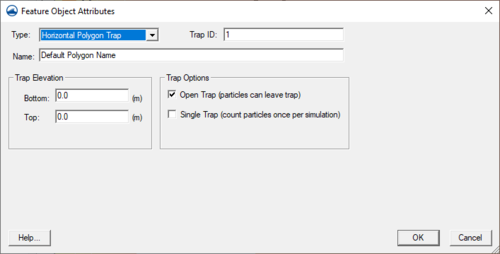
- The trap may be open (particles are free to leave) or closed.
- Particles can be counted once per simulation (single trap) or every time they re-enter an open trap.
- The trap can have a bottom and top elevation defining the portion of the water column the trap exists within.
- ID – Integer value to identify the trap
- Name – Text to identify the trap
PTM Polygon Attribute Dialog
The options for an individual trap can be set in the Feature Object Attributes dialog. The dialog is accessed by right-clicking on the trap polygon and selecting the Attributes menu command.
Horizontal Line Traps
Horizontal line traps lie in a vertical plane, defined by the trap end points and a top and bottom elevation.
Horizontal line traps have a direction associated with them. The direction of a trap determines which particles the trap will count.
- Decreasing x-coordinate – Only counts particles passing through the trap moving in the negative x-direction.
- Either direction – Counts particles passing through the trap regardless of direction.
- Increasing x-coordinate – Only counts particles passing through the trap moving in the positive x-direction.
Horizontal Polygon Traps
Horizontal polygon traps lie on a horizontal plane and are extruded in the vertical direction based on the trap's top and bottom elevation.
Related Topics
SMS – Surface-water Modeling System | ||
|---|---|---|
| Modules: | 1D Grid • Cartesian Grid • Curvilinear Grid • GIS • Map • Mesh • Particle • Quadtree • Raster • Scatter • UGrid |  |
| General Models: | 3D Structure • FVCOM • Generic • PTM | |
| Coastal Models: | ADCIRC • BOUSS-2D • CGWAVE • CMS-Flow • CMS-Wave • GenCade • STWAVE • WAM | |
| Riverine/Estuarine Models: | AdH • HEC-RAS • HYDRO AS-2D • RMA2 • RMA4 • SRH-2D • TUFLOW • TUFLOW FV | |
| Aquaveo • SMS Tutorials • SMS Workflows | ||
