SMS:PTM Model Control
The PTM model control is used to create the program control file, which contains general simulation options. Refer to the PTM manual for a more detailed description of how these parameters affect the model results.
Time
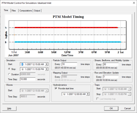
The Time tab is used to specify time information to be written to the program control file. If a control on the dialog is not enabled, the corresponding keyword will not be written to the program control file. Controls on the dialog are disabled based on the options chosen on the other model control tabs. For example, if no trap file is specified on the Files tab, the time controls related to traps will not be available. There is a plot on the dialog of the specified times. This tab has the following inpute fields:
- Simulation
- Start
- Stop
- Duration
- Time Step
- Particle Output
- Shear, Bedforms, and Mobility Updates
- Mapping Output
- Flow and Elevation Update
- Waves
- Start
- Time Step
- Hydrodynamics
- Traps
- Start
- Stop
- Last time step trap
Files
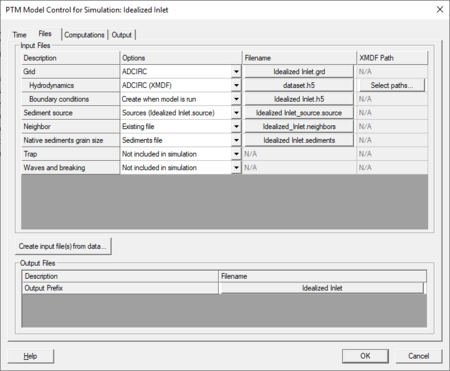
The Files tab is used to specify input and output file information to be written to the program control file (*.pcf).
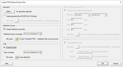
Pressing the Create input file(s) from data... button on the Files tab will open the Create PTM External Input Files dialog. This dialog can import results from ADCIRC, ADH, SRH-2D, CMS-FLOW or other models to create a mesh (fort.14) file, grain size native sediment (*.sediment) file, and/or a XMDF hydrodynamic input flow file (*.h5) to import into a PTM model. This option is not necessary for basic ADCIRC and CMS-FLOW models since their files will import into PTM if specified in the input files section.
- Note: SMS is not capable of importing RMA2 and FESWMS files into PTM at this time.
Native Sediment Grain Size
- If "Uniform bed" is selected from the "Options" column an Options button is displayed under "Filename". Pressing this button allows creating uniform grain sizes for D35, D50 and D90 (where D35 means 35% of the grains are smaller than diameter D). If the project is saved, the :SEDIMENT_FORMAT card is created, with the keyword UNIFORM and the 3 grain sizes being written out.
- If Sediment file is selected, manually select the file name by pressing the button under "Filename".
- Pressing the Create input file(s) from data and selecting to create a Native sediment grain size file will automatically toggle the native sediments grain size to "sediments file" and place the new file under the "Filename". The user can enter in the D values with the constant mobile bed type or a Nikuradse‘s equivalent sand roughness Ks (surface roughness height which equals D90) for the constant fixed bed type or use a dataset for spatially varied grain sizes.
Computations
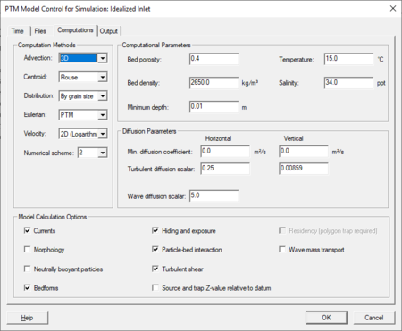
The Computations tab is used to specify model computation options to be written to the program control file. This tab has the following input fields:
- Computation Methods
- Advection
- Centroid
- Distribution
- Eulenian
- Velocity
- Numerical scheme
- Computational Parameters
- Bed porosity
- Temperature
- Bed density
- Salinity
- Minimum depth
- Diffusion Parameters
- Min. diffusion coefficient
- Turbulent diffusion scalar
- Wave diffusion scalar
- Model Calculation Options
- Currents
- Morphology
- Neutrally buoyant particles
- Bedforms
- Hiding and exposure
- Particle-bed interaction
- Turbulent shear
- Source and trap Z-value relative to datum
- Residency (polygon trap required)
- Wave mass transport
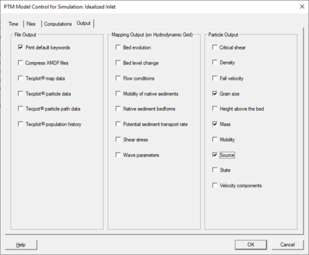
Output
The Output tab is used to specify model output options to be written to the program control file. This tab has the following input fields:
- File Output
- Print default keywords
- Compress XMDF files
- Tecplot map data
- Tecplot particle data
- Tecplot particle path data
- tecplot population history
- Mapping Output (on Hydrodynamic Grid)
- Bed evolution
- Bed level change
- Flow conditions
- Mobility of native sediments
- Native sediment bedforms
- Potential sediment transport rate
- Shear stress
- Wave parameters
- Particle Output
- Critical shear
- Density
- Fall velocity
- Grain size
- Height above the bed
- Mass
- Mobility
- Source
- State
- Velocity components
Related Topics
SMS – Surface-water Modeling System | ||
|---|---|---|
| Modules: | 1D Grid • Cartesian Grid • Curvilinear Grid • GIS • Map • Mesh • Particle • Quadtree • Raster • Scatter • UGrid |  |
| General Models: | 3D Structure • FVCOM • Generic • PTM | |
| Coastal Models: | ADCIRC • BOUSS-2D • CGWAVE • CMS-Flow • CMS-Wave • GenCade • STWAVE • WAM | |
| Riverine/Estuarine Models: | AdH • HEC-RAS • HYDRO AS-2D • RMA2 • RMA4 • SRH-2D • TUFLOW • TUFLOW FV | |
| Aquaveo • SMS Tutorials • SMS Workflows | ||
