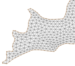
SMS:Paving
The paving method uses an advancing front technique to fill the polygon with elements. Based on the vertex distribution on the boundaries, equilateral triangles are created on the interior to define a smaller interior polygon. Overlapping regions are removed and the process is repeated until the region is filled. Interior nodal locations are relaxed to create better quality elements.
Both the Paving method and the Scalar Paving Density can be selected in the 2D Mesh Polygon Properties dialog. The dialog is accessed by right-clicking on the a polygon and selecting the Attributes command.
Scalar Paving Density
Scalar paving density utilizes the same approach as paving with the added component of a size dataset. A size dataset defines the desired spacing of nodes in a spatial fashion. A scattered dataset provides the geometric basis for the size dataset, and a dataset on the scatter set provides the values for the size dataset.
Prior to version 13.0 of SMS, the mesh generation process included a redistribution the vertices on the boundaries of the polygon to match the underlying size dataset. This potentially results in a new coverage with the redistribution. As part of version 13.0 of SMS, this feature was separated into its own function for flexibility. The redistribution of vertices on boundary arcs to match a size function was moved to the feature arc redistribution command. If the target size specified by the size function is significantly different from the distribution of the edges, poor mesh quality can result.
Constant Paving Density
Constant paving density utilizes the same approach as paving with the added component of a size and bias specified for each polygon. The paving algorithm generates elements that match the distribution of the vertices on the boundary, then transition to the target size as quickly as the bias term allows. Bias values close to 0.0 means elements make a slow transition from the polygon boundary, resulting in smaller elements. Bias values close to 1.0 means elements make a fast transition, resulting in larger elements.
If the polygon boundary defines features for which high resolution is desired, such as stream centerlines, the polygon's "Size" attribute could be set to a larger size to allow for efficient mesh generation.
Conversely if the polygon boundary represents features far away from the area of interest such as a far flood plane limit, the polygon's "Size" attribute could be set to a smaller size. For smooth transition of element size, the recommended value for the bias should be less than 0.3.
Related Topics
| [hide] SMS – Surface-water Modeling System | ||
|---|---|---|
| Modules: | 1D Grid • Cartesian Grid • Curvilinear Grid • GIS • Map • Mesh • Particle • Quadtree • Raster • Scatter • UGrid |  |
| General Models: | 3D Structure • FVCOM • Generic • PTM | |
| Coastal Models: | ADCIRC • BOUSS-2D • CGWAVE • CMS-Flow • CMS-Wave • GenCade • STWAVE • WAM | |
| Riverine/Estuarine Models: | AdH • HEC-RAS • HYDRO AS-2D • RMA2 • RMA4 • SRH-2D • TUFLOW • TUFLOW FV | |
| Aquaveo • SMS Tutorials • SMS Workflows | ||
