SMS:Grid Smoothing: Difference between revisions
From XMS Wiki
Jump to navigationJump to search
No edit summary |
(Corrected spelling of 'and') |
||
| Line 1: | Line 1: | ||
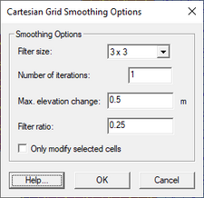
[[File:Cartesian Grid Smoothing Options.jpg|thumb|225 px|''Cartesian Grid Smoothing Options'' dialog]] | [[File:Cartesian Grid Smoothing Options.jpg|thumb|225 px|''Cartesian Grid Smoothing Options'' dialog]] | ||
The ''Cartesian Grid Smoothing Options'' dialog is opened by right-clicking on a Cartesian Grid item in the [[SMS:Project Explorer|Project Explorer]] | The ''Cartesian Grid Smoothing Options'' dialog is opened by right-clicking on a Cartesian Grid item in the [[SMS:Project Explorer|Project Explorer]] and selecting the '''Smooth...''' menu command. The following options can be specified: | ||
* ''Filter size'' – This determines how many neighbors are included when smoothing the grid. Options are 3x3 and 5x5. | * ''Filter size'' – This determines how many neighbors are included when smoothing the grid. Options are 3x3 and 5x5. | ||
* ''Number of iterations'' – This specifies how many passes should be made with the smoothing algorithm. | * ''Number of iterations'' – This specifies how many passes should be made with the smoothing algorithm. | ||
Revision as of 22:32, 2 February 2017
The Cartesian Grid Smoothing Options dialog is opened by right-clicking on a Cartesian Grid item in the Project Explorer and selecting the Smooth... menu command. The following options can be specified:
- Filter size – This determines how many neighbors are included when smoothing the grid. Options are 3x3 and 5x5.
- Number of iterations – This specifies how many passes should be made with the smoothing algorithm.
- Max. elevation change – This value specifies the maximum allowable elevation change per iteration for each cell.
- Filter ratio – The new cell elevation is computed using the original elevation (at the beginning of the iteration not the whole process) and the "blurred" elevation. The filter ratio defines how far the elevation is changed between the original elevation and the "blurred" elevation. A filter ratio of 1.0 would replace the existing elevation with the "blurred" elevation. A filter ratio of 0.0 would be pointless as it wouldn't change the elevations. A filter ratio of 0.5 would give a new elevation that is the average of the original elevation and the blurred elevation.
- Filter Range – The start and end index values specify the extents of the smoothing. Defaults to the grid extents.
- Column start – The column index on which to start the smoothing process.
- Column end – The column index on which to end the smoothing process.
- Row start – The row index on which to start the smoothing process.
- Row end – The row index on which to end the smoothing process.
Related Topics
SMS – Surface-water Modeling System | ||
|---|---|---|
| Modules: | 1D Grid • Cartesian Grid • Curvilinear Grid • GIS • Map • Mesh • Particle • Quadtree • Raster • Scatter • UGrid |  |
| General Models: | 3D Structure • FVCOM • Generic • PTM | |
| Coastal Models: | ADCIRC • BOUSS-2D • CGWAVE • CMS-Flow • CMS-Wave • GenCade • STWAVE • WAM | |
| Riverine/Estuarine Models: | AdH • HEC-RAS • HYDRO AS-2D • RMA2 • RMA4 • SRH-2D • TUFLOW • TUFLOW FV | |
| Aquaveo • SMS Tutorials • SMS Workflows | ||
