GMS:TIN Module: Difference between revisions
From XMS Wiki
Jump to navigationJump to search
No edit summary |
No edit summary |
||
| (12 intermediate revisions by 3 users not shown) | |||
| Line 2: | Line 2: | ||
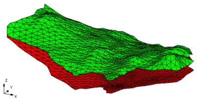
TIN stands for Triangulated Irregular Network. TINs are used for surface modeling. TINs are formed by connecting a set of XYZ points with edges to form a network of triangles. TINs can be used to represent the surface of a geologic unit or the surface defined by a mathematical function. | TIN stands for Triangulated Irregular Network. TINs are used for surface modeling. TINs are formed by connecting a set of XYZ points with edges to form a network of triangles. TINs can be used to represent the surface of a geologic unit or the surface defined by a mathematical function. | ||
By default, GMS uses the Delaunay criterion to [[GMS:Triangulation|triangulate]] TINs. | TINs in GMS can be [[GMS:Creating a TIN|created]] manually, imported, or created from other data objects. By default, GMS uses the Delaunay criterion to [[GMS:Triangulation|triangulate]] TINs. | ||
GMS provides a variety of [[GMS:TIN Tool Palette|tools]] and [[GMS:TIN Commands|commands]] for manipulating TINs | GMS provides a variety of [[GMS:TIN Tool Palette|tools]] and [[GMS:TIN Commands|commands]] for [[GMS:Editing a TIN|manipulating]] TINs. TINs can be contoured, displayed in oblique view with mapped images and hidden surfaces removed, and have several other [[GMS:TIN Display Options|display options]] that can be set to visualize and understand the terrain surface better. GMS also contains custom [[GMS:TIN Settings|settings]] for using TINs and allows TINs to be [[GMS:Converting TINS to Other Data Types|converted]] into other types of data, including [[GMS:Building Solids and 3D Meshes with TINs|solid models and 3D meshes]]. Through GMS it is possible to both import and export [[TIN Files|TIN files]]. | ||
Several TINs can be modeled at once in GMS. One of the TINs is designated as the "active" TIN. The selection and [[GMS:Editing a TIN|editing tools]] apply to the active TIN only. | Several TINs can be modeled at once in GMS. One of the TINs is designated as the "active" TIN. The selection and [[GMS:Editing a TIN|editing tools]] apply to the active TIN only. | ||
[[Image:tins.png|thumb| | :[[Image:tins.png|thumb|none|400px|Example of a TIN in GMS]] | ||
The TIN module can be added to a [http://www.aquaveo.com/software/gms-pricing paid edition] of GMS by purchasing the Subsurface Characterization Tools. | |||
[[Category:Link to Store]] | |||
{{Navbox GMS}} | {{Navbox GMS}} | ||
[[Category:TINs]] | [[Category:TINs]] | ||

