SMS:GIS Module Tools: Difference between revisions
From XMS Wiki
Jump to navigationJump to search
No edit summary |
|||
| (12 intermediate revisions by one other user not shown) | |||
| Line 1: | Line 1: | ||
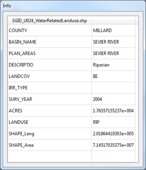
[[File:GIS Get ArcObject Attributes Info.png|thumb|300 px|Example of the ''Info'' dialog that appears when using the '''Get Attributes''' tool]] | [[File:GIS Get ArcObject Attributes Info.png|thumb|300 px|Example of the ''Info'' dialog that appears when using the '''Get Attributes''' tool]] | ||
The following tools are active in the dynamic portion of the Tool Palette whenever the GIS module is active. Only one tool is active at any given time. The action that takes place when | The following tools are active in the dynamic portion of the Tool Palette whenever the GIS module is active. Only one tool is active at any given time. The action that takes place when clicking in the Graphics Window with the cursor depends on the current tool. The tools in the GIS tool palette are described below: | ||
; '''Select ArcObject''' [[ | ; '''Select ArcObject''' [[File:Select ArcObject Tool.svg|15 px]] : The '''Select ArcObject''' tool is used to select ArcObjects in the Graphics Window. Selected objects can be mapped to other data types. This tool is only available if ArcView is installed locally and enabled in SMS. | ||
; '''Get Attributes''' [[ | ; '''Get Attributes''' [[File:Identify Tool.svg|16px]] : The '''Get Attributes''' tool is used to select GIS objects and display information relating to that object in an ''Info'' dialog. | ||
; '''Select''' [[File:Select Object | ; '''Select''' [[File:Select Object Tool.svg|8 px]] : The '''Select''' tool is used to select shape objects in the Graphics Window. Selected objects can be mapped to other data types. | ||
Unlike other modules in SMS, the GIS module tools do not have any right-click menu commands. | |||
==Get Attributes Tool Info Dialog== | ==Get Attributes Tool Info Dialog== | ||
Clicking on an object when using the '''Get Attributes''' tool will bring up the GIS attributes ''Info'' dialog. The attributes shown in this dialog are based on the GIS file data. The dialog is closed by selecting another tool. | Clicking on an object when using the '''Get Attributes''' tool will bring up the GIS attributes ''Info'' dialog. The attributes shown in this dialog are based on the GIS file data. Attributes cannot be edited in this dialog. The dialog is closed by selecting another tool. | ||
== Related Topics == | == Related Topics == | ||
| Line 16: | Line 17: | ||
{{Template:Navbox SMS}} | {{Template:Navbox SMS}} | ||
[[Category:SMS GIS| | [[Category:SMS GIS|Tools]] | ||
[[Category:SMS_Tools| | [[Category:SMS_Tools|GIS]] | ||
[[Category:SMS GIS Dialogs]] | [[Category:SMS GIS Dialogs|Tools]] | ||
Latest revision as of 19:25, 21 November 2017
The following tools are active in the dynamic portion of the Tool Palette whenever the GIS module is active. Only one tool is active at any given time. The action that takes place when clicking in the Graphics Window with the cursor depends on the current tool. The tools in the GIS tool palette are described below:
- Select ArcObject

- The Select ArcObject tool is used to select ArcObjects in the Graphics Window. Selected objects can be mapped to other data types. This tool is only available if ArcView is installed locally and enabled in SMS.
- Get Attributes

- The Get Attributes tool is used to select GIS objects and display information relating to that object in an Info dialog.
- Select

- The Select tool is used to select shape objects in the Graphics Window. Selected objects can be mapped to other data types.
Unlike other modules in SMS, the GIS module tools do not have any right-click menu commands.
Get Attributes Tool Info Dialog
Clicking on an object when using the Get Attributes tool will bring up the GIS attributes Info dialog. The attributes shown in this dialog are based on the GIS file data. Attributes cannot be edited in this dialog. The dialog is closed by selecting another tool.
Related Topics
SMS Toolbars | |
|---|---|
| Standard Toolbars: | Data • Macros (Display, File, Optional Macro) • Module Toolbar • Static Tools |
| Dynamic Tools | 1D Grid • 2D Mesh Module • Annotations • Cartesian Grid Module • Curvilinear Grid • GIS Module • Map Module • Particle Module • Quadtree • Scatter Module |
| Quick Tour • Layout | |
SMS – Surface-water Modeling System | ||
|---|---|---|
| Modules: | 1D Grid • Cartesian Grid • Curvilinear Grid • GIS • Map • Mesh • Particle • Quadtree • Raster • Scatter • UGrid |  |
| General Models: | 3D Structure • FVCOM • Generic • PTM | |
| Coastal Models: | ADCIRC • BOUSS-2D • CGWAVE • CMS-Flow • CMS-Wave • GenCade • STWAVE • WAM | |
| Riverine/Estuarine Models: | AdH • HEC-RAS • HYDRO AS-2D • RMA2 • RMA4 • SRH-2D • TUFLOW • TUFLOW FV | |
| Aquaveo • SMS Tutorials • SMS Workflows | ||
