AHGW:Import Georeferenced MODFLOW Model: Difference between revisions
From XMS Wiki
Jump to navigationJump to search
m (Added a category) |
m (Move page script moved page AHGW:Import Georeferenced MODFLOW Model to Test:Import Georeferenced MODFLOW Model without leaving a redirect) |
(No difference)
| |
Latest revision as of 23:40, 9 September 2019
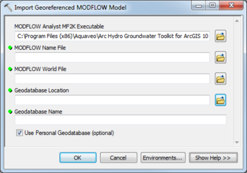
The Import Georeferenced MODFLOW Model tool is accessed by double-clicking on "![]() Import Georeferenced MODFLOW Model" under the "
Import Georeferenced MODFLOW Model" under the "![]() Import" toolset under the "
Import" toolset under the "![]() MODFLOW Analyst" toolset under the "
MODFLOW Analyst" toolset under the "![]() Arc Hydro Groundwater Tools" toolbox.
Arc Hydro Groundwater Tools" toolbox.
The following fields are available. Required fields are marked with a ![]() icon. Fields marked with a
icon. Fields marked with a ![]() icon may either not be supported or the table doesn't exist.
icon may either not be supported or the table doesn't exist.
- MODFLOW Analyst MF2K Executable – Click the
 button to bring up the Open dialog in order to specify the location (local path) of the MODFLOW Analyst MF2K executable. This executable reads the MODFLOW files and exports them to a geodatabase.
  MODFLOW Name File – Click the
  button to bring up the Open dialog in order to specify the Name File of the MODFLOW simulation. Usually has a .nam or .mfn extension.
 MODFLOW World File – Click the
  button to bring up the Open dialog in order to specify the MODFLOW World file, which contains information about the origin of the MODFLOW simulation and coordinate system. Usually has a .mfw extension.
 Geodatabase Location – Click the
  button to bring up the Geodatabase Location dialog in order to specify the location where the geodatabase will be stored.
 Geodatabase Name – Name of the geodatabase to be created.
- Use Personal Geodatabase – Optional. Turn on to specify creating a personal geodatabase. Turn off to specify creating a file geodatabase.

