AHGW:Add to Raster Series
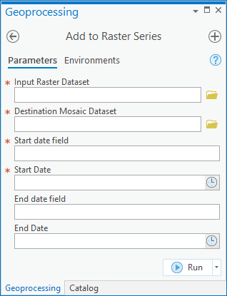
The Add to Raster Series tool is accessed in the Geoprocessing pane by double-clicking on "![]() Add to Raster Series" under the "
Add to Raster Series" under the "![]() Groundwater Analyst" toolset under the "
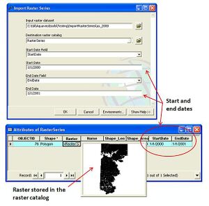
Groundwater Analyst" toolset under the "![]() ArcHydroGroundwater.pyt" toolbox. This tool imports a raster dataset into a mosaic dataset and attributes the raster with start and end dates/times. The start and end dates/times represent the time period of the data stored in the raster, and can be used for animating a series of rasters stored in the catalog.
ArcHydroGroundwater.pyt" toolbox. This tool imports a raster dataset into a mosaic dataset and attributes the raster with start and end dates/times. The start and end dates/times represent the time period of the data stored in the raster, and can be used for animating a series of rasters stored in the catalog.
- ArcGIS Note – In older versions of ArcGIS, this tool appears as a dialog and is accessed through the "Arc Hydro Groundwater Tools" toolbox. The fields remain almost entirely the same. In ArcGIS, there are raster catalogs. Raster catalogs were replaced by mosaic datasets in ArcGIS Pro. The icons also vary between ArcGIS and ArcGIS Pro.
The following fields are available. Required fields are marked with a ![]() icon.
icon.
 Input Raster Dataset – Click the
  button to bring up the Input Raster Dataset dialog in order to specify the raster dataset to be imported.
 Destination Mosaic Dataset – Click the
  button to bring up the Destination Mosaic Dataset dialog in order to specify the destination mosaic dataset.
 Start Date Field – Select from the drop-down the date field representing the start date of the raster data.
 Start Date – Click the
  button to select the start date/time value to assign to the start date field.
- End Date Field – Optional. Select from the drop-down the date field representing the end date of the raster data.
- End Date – Optional. Click the
 button to select the start date/time value to assign to the start date field.
Batches and Automation
The AHGW Pro Add to Raster Series tool loads a raster dataset into a mosaic dataset and attributes the raster with a start and end date/time. The start and end date/time represent the time period of the data stored in the raster, and can be used for animating a series of rasters stored in the dataset.
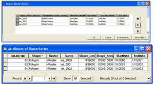
In addition to importing a single raster, the tool has a batch mode for importing a set of rasters into the dataset and attributing them with the appropriate date/time values.
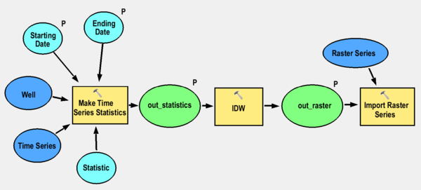
To automate the process of generating a set of raster series from point features and time series data, the tool can be combined in a model with the Make Time Series Statistics tool. The following image shows a model that:
- Creates time series statistics from given points and tabular time series,
- Interpolates the points to a raster, and
- Imports the raster to a raster catalog and attributes the rasters with appropriate date/time values.
| [show] AHGW – Arc Hydro Groundwater Toolbox |
|---|


