AHGW:IBOUND to Polygon: Difference between revisions
From XMS Wiki
Jump to navigationJump to search
(Created page with "350px|thumb|right|''IBOUND to Polygon'' dialog The ''IBOUND to Polygon'' tool is accessed by double-clicking on "...") |
m (Move page script moved page AHGW:IBOUND to Polygon to Test:IBOUND to Polygon without leaving a redirect) |
Latest revision as of 23:40, 9 September 2019
The IBOUND to Polygon tool is accessed by double-clicking on "![]() IBOUND to Polygon" under the "
IBOUND to Polygon" under the "![]() Views" toolset under the "
Views" toolset under the "![]() MODFLOW Analyst" toolset under the "
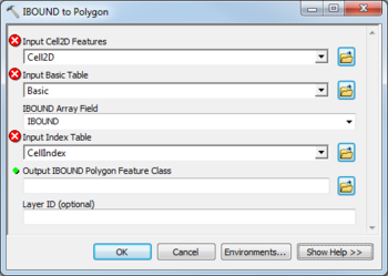
MODFLOW Analyst" toolset under the "![]() Arc Hydro Groundwater Tools" toolbox. This tool creates an active area polygon feature class from a Cell2D layer. The extents of the active areas are determined by an IBOUND array.
Arc Hydro Groundwater Tools" toolbox. This tool creates an active area polygon feature class from a Cell2D layer. The extents of the active areas are determined by an IBOUND array.
The following fields are available. Required fields are marked with a ![]() icon. Fields marked with a
icon. Fields marked with a ![]() icon may either not be supported or the table doesn't exist.
icon may either not be supported or the table doesn't exist.
- Input Cell2D Features – Click the
 button to bring up the Input Cell2D Features dialog in order to specify the polygon layer representing the Cell2D layer of MODFLOW grid cells.
 - Input Basic Table – Click the
 button to bring up the Input Basic Table dialog in order to specify the Basic table, part of the MODFLOW Data Model, containing the IBOUND array.
 - IBOUND Array Table – Select from the drop-down the field in the Basic table that represents the IBOUND array.
- Input Index Table – Click the
 button to bring up the Input Index Table dialog in order to specify the CellIndex table.
  Output IBOUND Polygon Feature Class – Click the
  button to bring up the Output IBOUND Polygon Feature Class dialog in order to specify the resulting polygon feature class containing the active area polygons.
- Layer ID – Optional. Enter the MODFLOW layer (K) ID. If left empty the tool will create an active area polygon for each of the MODFLOW layers.

