AHGW:Troubleshooting 3D Bore Lines: Difference between revisions
From XMS Wiki
Jump to navigationJump to search
No edit summary |
No edit summary |
||
| Line 1: | Line 1: | ||
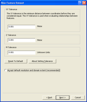
In many cases, this problem is related to the dimensions of the feature classes. | [[File:AHGW New Feature Dataset dialog.png|thumb|right|350px|The first page of the ''New Feature Dataset'' dialog.]] | ||
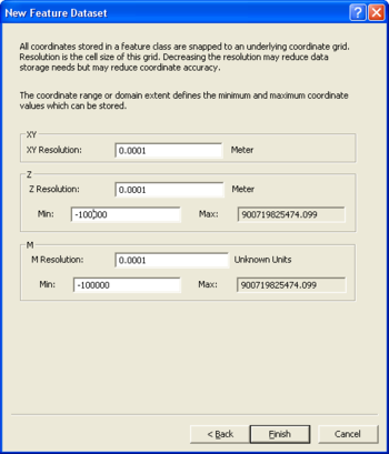
[[File:AHGW New Feature Dataset dialog 2.png|thumb|right|350px|The second page of the ''New Feature Dataset'' dialog.]] | |||
In many cases, this problem is related to the dimensions of the feature classes. Feature datasets and feature classes are often created with a limited Z domain with a value of set "0" as the minimum Z value, so features with elevations below "0" cannot be written to the feature classes in this feature dataset. | |||
Redefine the Z domain by doing the following: | |||
*Create a [[AHGW:Create Blank AHGW Geodatabase|new geodatabase]] | |||
*Create a new geodatabase | *Create a [http://desktop.arcgis.com/en/arcmap/10.5/manage-data/feature-datasets/creating-mole-data-in-arccatalog-creating-a-featur.htm new feature dataset] | ||
*Create a new feature dataset | *Make sure your feature dataset has the appropriate units (feet, meter) so that x, y, and z units are the same and match the vertical data in the BoreholeLog table. | ||
* | |||
*When you create the new feature dataset and get to the step defining the vertical coordinate system you will need to select one appropriate for your area. | *When you create the new feature dataset and get to the step defining the vertical coordinate system you will need to select one appropriate for your area. | ||
* | *Turn off "Accept default resolution and domain extent". | ||
*Click '''Next''' to go to the second page of the ''New Feature Dataset'' dialog. | |||
*In the ''Z'' section, enter a ''Min'' value that will include your data range. | |||
* In the | *Click '''Finish''' to create the feature dataset. | ||
*Load the data (wells, boreline) you have into the new feature dataset. | |||
*Run the [[AHGW:Create Borelines|''Create BoreLines'']] tool with the data in the new feature dataset. | |||
* | |||
* Load the data (wells, boreline) you have into the new feature dataset. | |||
* Run the ''Create BoreLines'' tool with the data in the new feature dataset. | |||
{{Navbox AHGW}} | {{Navbox AHGW}} | ||
[[Category:AHGW General Information]] | [[Category:AHGW General Information]] | ||
[[Category:Help]] | |||
Revision as of 21:44, 14 November 2019
In many cases, this problem is related to the dimensions of the feature classes. Feature datasets and feature classes are often created with a limited Z domain with a value of set "0" as the minimum Z value, so features with elevations below "0" cannot be written to the feature classes in this feature dataset.
Redefine the Z domain by doing the following:
- Create a new geodatabase
- Create a new feature dataset
- Make sure your feature dataset has the appropriate units (feet, meter) so that x, y, and z units are the same and match the vertical data in the BoreholeLog table.
- When you create the new feature dataset and get to the step defining the vertical coordinate system you will need to select one appropriate for your area.
- Turn off "Accept default resolution and domain extent".
- Click Next to go to the second page of the New Feature Dataset dialog.
- In the Z section, enter a Min value that will include your data range.
- Click Finish to create the feature dataset.
- Load the data (wells, boreline) you have into the new feature dataset.
- Run the Create BoreLines tool with the data in the new feature dataset.


