User:Rcorrigan/AHGW:Create Blank AHGW Geodatabase Pro: Difference between revisions
From XMS Wiki
Jump to navigationJump to search
No edit summary |
No edit summary |
||
| (5 intermediate revisions by the same user not shown) | |||
| Line 1: | Line 1: | ||
__NOINDEX__ | __NOINDEX__ | ||
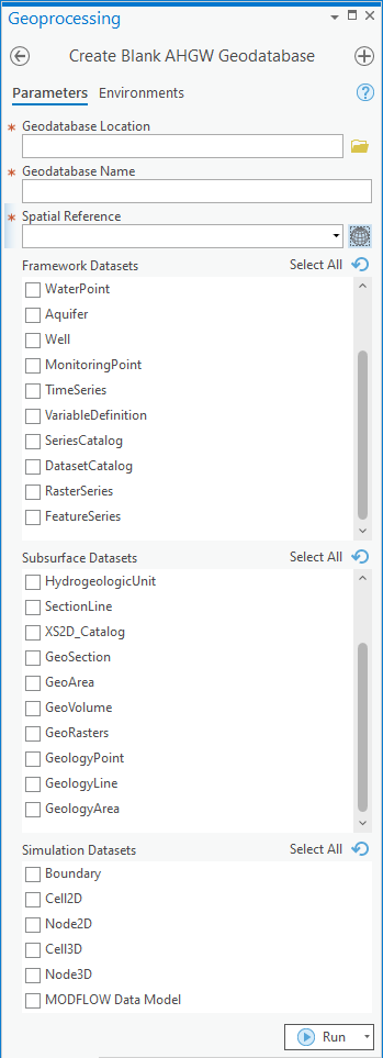
[[File:Create | [[File:ArcGIS Pro Create Blnk AHGW Geodtabse.png|350px|thumb|right|''Create Blank AHGW Geodatabase'' tool in the ''Geoprocessing'' pane]] | ||
The ''Create Blank AHGW Geodatabase'' tool is accessed by double-clicking on "[[File:ArcGISPro Toolbx Tool.png|16 px]] Create Blank AHGW Geodatabase" under the "[[File:ArcGISPro Toolset.png|16 px]] Groundwater Analyst" toolset under the "[[File:ArcGISPro Toolbx Item.png|16 px]] ArcHydroGroundwater.pyt" toolbox. | The ''Create Blank AHGW Geodatabase'' tool is accessed by double-clicking on "[[File:ArcGISPro Toolbx Tool.png|16 px]] Create Blank AHGW Geodatabase" under the "[[File:ArcGISPro Toolset.png|16 px]] Groundwater Analyst" toolset under the "[[File:ArcGISPro Toolbx Item.png|16 px]] ArcHydroGroundwater.pyt" toolbox. | ||
:'''''ArcGIS Note''''' – In older versions of ArcGIS, this tool appears as a dialog and is accessed through the "Arc Hydro Groundwater Tools" toolbox. | :'''''ArcGIS Note''''' – In older versions of ArcGIS, this tool appears as a dialog and is accessed through the "Arc Hydro Groundwater Tools" toolbox. | ||
| Line 8: | Line 8: | ||
*[[File:ArcGIS Pro Red Required Symbol.png|8 px]] ''Geodatabase Name'' – Enter the desired geodatabase name. | *[[File:ArcGIS Pro Red Required Symbol.png|8 px]] ''Geodatabase Name'' – Enter the desired geodatabase name. | ||
*[[File:ArcGIS Pro Red Required Symbol.png|8 px]] ''Spatial Reference'' – Click the [[File:ArcGISPro SlctCoordnateSystm.png|16 px]] button to bring up the ''Coordinate System'' dialog where the desired coordinate system can be selected. | *[[File:ArcGIS Pro Red Required Symbol.png|8 px]] ''Spatial Reference'' – Click the [[File:ArcGISPro SlctCoordnateSystm.png|16 px]] button to bring up the ''Coordinate System'' dialog where the desired coordinate system can be selected. | ||
:'''''ArcGIS Feature''''' – The | ::'''''ArcGIS Feature''''' – The following option is only available in older versions of ArcGIS, not in ArcGIS Pro. | ||
:*''Use Personal Geodatabase'' – Turn on to create a personal geodatabase. Turn off to create a file geodatabase. | :*''Use Personal Geodatabase'' – Turn on to create a personal geodatabase. Turn off to create a file geodatabase. | ||
*''Framework Datasets | *''Framework Datasets'' – Select which Feature Classes and Tables from the Framework and Temporal sections of the [[AHGW:Arc Hydro Groundwater Data Model|AHGW Data Model]] to create. Options include: | ||
**"WaterLine" | **"WaterLine" | ||
**"WaterBody" | **"WaterBody" | ||
| Line 24: | Line 24: | ||
**"RasterSeries" | **"RasterSeries" | ||
**"FeatureSeries" | **"FeatureSeries" | ||
*''Subsurface Datasets | *''Subsurface Datasets'' – Select which Feature Classes and Tables from the Borehole, Hydrostratigraphy, and Geology sections of the [[AHGW:Arc Hydro Groundwater Data Model|AHGW Data Model]] to create. Options include: | ||
**"BoreholeLog" | **"BoreholeLog" | ||
**"BorePoint" | **"BorePoint" | ||
| Line 38: | Line 38: | ||
**"GeologyLine" | **"GeologyLine" | ||
**"GeologyArea" | **"GeologyArea" | ||
*''Simulation Datasets | *''Simulation Datasets'' – Select which Feature Classes and Tables from the Simulation section of the [[AHGW:Arc Hydro Groundwater Data Model|AHGW Data Model]] to create, along with the [[AHGW:MODFLOW Data Model|MODFLOW Data Model]]. Options include: | ||
**"Boundary" | **"Boundary" | ||
**"Cell2D" | **"Cell2D" | ||
Latest revision as of 20:26, 11 August 2022
The Create Blank AHGW Geodatabase tool is accessed by double-clicking on "![]() Create Blank AHGW Geodatabase" under the "
Create Blank AHGW Geodatabase" under the "![]() Groundwater Analyst" toolset under the "
Groundwater Analyst" toolset under the "![]() ArcHydroGroundwater.pyt" toolbox.
ArcHydroGroundwater.pyt" toolbox.
- ArcGIS Note – In older versions of ArcGIS, this tool appears as a dialog and is accessed through the "Arc Hydro Groundwater Tools" toolbox.
- The icons vary between ArcGIS and ArcGIS Pro.
The following fields are available. Required fields are marked with a ![]() icon. In ArcGIS, they are marked with a
icon. In ArcGIS, they are marked with a ![]() icon.
icon.
 Geodatabase Location – Click the
  button to bring up the Geodatabase Location dialog in order to select the location where the geodatabase will be stored.
 Geodatabase Name – Enter the desired geodatabase name.
 Spatial Reference – Click the
  button to bring up the Coordinate System dialog where the desired coordinate system can be selected.
- ArcGIS Feature – The following option is only available in older versions of ArcGIS, not in ArcGIS Pro.
- Use Personal Geodatabase – Turn on to create a personal geodatabase. Turn off to create a file geodatabase.
- Framework Datasets – Select which Feature Classes and Tables from the Framework and Temporal sections of the AHGW Data Model to create. Options include:
- "WaterLine"
- "WaterBody"
- "Watershed"
- "WaterPoint"
- "Aquifer"
- "Well"
- "MonitoringPoint"
- "TimeSeries"
- "VariableDefinition"
- "SeriesCatalog"
- "DatasetCatalog"
- "RasterSeries"
- "FeatureSeries"
- Subsurface Datasets – Select which Feature Classes and Tables from the Borehole, Hydrostratigraphy, and Geology sections of the AHGW Data Model to create. Options include:
- "BoreholeLog"
- "BorePoint"
- "BoreLine"
- "HydrogeologicUnit"
- "SectionLine"
- "XS2D_Catalog"
- "GeoSection"
- "GeoArea"
- "GeoVolume"
- "GeoRasters"
- "GeologyPoint"
- "GeologyLine"
- "GeologyArea"
- Simulation Datasets – Select which Feature Classes and Tables from the Simulation section of the AHGW Data Model to create, along with the MODFLOW Data Model. Options include:
- "Boundary"
- "Cell2D"
- "Node2D"
- "Cell3D"
- "Bode3D"
- "MODFLOW Data Model"

