SMS:Object Info: Difference between revisions
| (27 intermediate revisions by 2 users not shown) | |||
| Line 1: | Line 1: | ||
Object information for a module can be found by clicking on the [[File:GMS Properties Macro.svg|16 px]] '''Get Module Info''' macro or using the '''Get Info''' command in the ''File'' menu. | |||
==Information Dialog== | ==Information Dialog== | ||
The '''Get Info''' command reports basic information concerning the data type associated with the active module. Information is available for the following modules: | The '''Get Info''' command reports basic information concerning the data type associated with the active module. Information is available for the following modules: | ||
===Cartesian Grid Module Information=== | ===Cartesian Grid Module Information=== | ||
[[Image:SMS Info Carte. | [[Image:SMS Info Carte.png|thumb|400 px|''Information'' dialog showing the Cartesian Grid Module'' tab]] | ||
The following information is shown on the [[SMS:Cartesian Grid Module|''Cartesian Grid Module'']] tab of the ''Information'' dialog: | The following information is shown on the [[SMS:Cartesian Grid Module|''Cartesian Grid Module'']] tab of the ''Information'' dialog: | ||
*Number of cells | *Number of cells | ||
| Line 15: | Line 17: | ||
*Number of ocean cells | *Number of ocean cells | ||
*Number of land cells | *Number of land cells | ||
===GIS Module Information=== | |||
The following information is shown on the [[SMS:GIS Module|''GIS Module'']] tab of the ''Information'' dialog: | |||
*Number of images | |||
*Number of DEMs | |||
*GIS selector dropdown | |||
*Type | |||
*Global Min | |||
*Global Max | |||
*Data min | |||
*Data max | |||
===Map Module Information=== | ===Map Module Information=== | ||
[[Image:SMS Get Info Map. | [[Image:SMS Get Info Map.png|thumb|400 px|''Information'' dialog showing the ''Map Module'' tab]] | ||
The following information is shown on the [[SMS:Map Module|''Map Module'']] tab of the ''Information'' dialog: | The following information is shown on the [[SMS:Map Module|''Map Module'']] tab of the ''Information'' dialog: | ||
*For all coverages: | *For all coverages: | ||
**Number of points | |||
*Number of points | **Number of nodes / vertices | ||
*Number of nodes / vertices | **Number of arcs | ||
*Number of arcs | **Number of polygons | ||
*Number of polygons | |||
*For selected coverage: | *For selected coverage: | ||
:The drop down menu will list all available coverages. Select a coverage to view information. | |||
*Number of points | :*The type of the current coverage | ||
*Number of nodes / vertices | :*Number of points | ||
*Number of arcs | :*Number of nodes / vertices | ||
*Number of polygons | :*Number of arcs | ||
:*Number of polygons | |||
===Mesh Module Information=== | ===Mesh Module Information=== | ||
[[Image:SMS Info Mesh. | [[Image:SMS Info Mesh.png|thumb|400 px|''Information'' dialog showing the ''Mesh Module'' tab]] | ||
The following information is shown on the [[SMS:Mesh Module|''Mesh Module'']] tab of the ''Information'' dialog: | The following information is shown on the [[SMS:Mesh Module|''Mesh Module'']] tab of the ''Information'' dialog: | ||
*Maximum element front width | *Maximum element front width | ||
| Line 49: | Line 60: | ||
*Number of quadrilateral elements | *Number of quadrilateral elements | ||
*Model specific Info | *Model specific Info | ||
**[[SMS:RMA2|RMA2]] | |||
*[[SMS:RMA2|RMA2]] | ***Transition elements | ||
***Junction elements | |||
*Transition elements | ***Control elements | ||
*Junction elements | ***Linear elements | ||
*Control elements | ***1D nodes without 1D | ||
*Linear elements | **[[SMS:FESWMS|FESWMS]] | ||
*1D nodes without 1D | ***Number of [[SMS:FESWMS Hydraulic Structures#Culvert|culverts]] | ||
***Number of [[SMS:FESWMS Hydraulic Structures#Piers|piers]] | |||
*[[SMS:FESWMS|FESWMS]] | ***Number of [[SMS:FESWMS Hydraulic Structures#Weir|weirs]] | ||
***Number of [[SMS:FESWMS Hydraulic Structures#Drop-Inlet Spillways|drop inlets]] | |||
*Number of [[SMS:FESWMS Hydraulic Structures#Culvert|culverts]] | ***Max ceiling value | ||
*Number of [[SMS:FESWMS Hydraulic Structures#Piers|piers]] | ***Min ceiling value | ||
*Number of [[SMS:FESWMS Hydraulic Structures#Weir|weirs]] | **[[SMS:Generic Mesh Model|Generic Mesh Model]] | ||
*Number of [[SMS:FESWMS Hydraulic Structures#Drop-Inlet Spillways|drop inlets]] | ***Model name | ||
*Max ceiling value | |||
*Min ceiling value | |||
*[[SMS:Generic Mesh Model|Generic Mesh Model]] | |||
*Model name | |||
===Scatter Module Information=== | ===Scatter Module Information=== | ||
[[Image:SMS Info Scatter. | [[Image:SMS Info Scatter.png|thumb|400 px|''Information'' dialog showing the ''Scatter Module'' page]] | ||
The following information is shown on the [[SMS:Scatter Module|''Scatter Module'']] tab of the ''Information'' dialog: | The following information is shown on the [[SMS:Scatter Module|''Scatter Module'']] tab of the ''Information'' dialog: | ||
*For all scatter sets | *For all scatter sets | ||
**Number of points | |||
*Number of points | **Number of triangles | ||
*Number of triangles | |||
*For selected scatter sets | *For selected scatter sets | ||
:The drop down menu will list all available scatter sets. Select a scatter set to view information. | |||
*Scatter set ID | :*Scatter set ID | ||
*Number of points | :*Number of points | ||
*Number of triangles | :*Number of triangles | ||
===UGrid Module Information=== | |||
The following information is shown on the [[SMS:UGrid Module|''UGrid Module'']] tab of the ''Information'' dialog: | |||
*Number of cells | |||
*Maximum cell id | |||
*Number of points | |||
*Maximum point id | |||
*Minimum Z value | |||
*Maximum Z value | |||
*Element type | |||
*Num. of triangular cells | |||
*Num. of quadrilateral cells | |||
*Constraint type | |||
*Origin X | |||
*Origin Y | |||
*Angle | |||
<!-- | |||
===Raster Module Information=== | ===Raster Module Information=== | ||
[[Image:SMS Info Raster.jpg|thumb|none|left|400 px|''Information'' dialog showing the ''Raster Module'' tab]] | [[Image:SMS Info Raster.jpg|thumb|none|left|400 px|''Information'' dialog showing the ''Raster Module'' tab]] | ||
The following information is shown on the [[SMS:Raster Module|''Raster Module'']] tab of the ''Information'' dialog: | The following information is shown on the [[SMS:Raster Module|''Raster Module'']] tab of the ''Information'' dialog: | ||
* All DEMS (1) | * All DEMS (1) | ||
** Number of points: | |||
* Number of points: | ** Number of cells: | ||
* Number of cells: | ** Minimum Z value | ||
* Minimum Z value | ** Maximum Z value | ||
* Maximum Z value | |||
* Selected | * Selected | ||
:The drop down menu will list all available raster sets. Select a raster set to view information. | |||
* Number of points | :* Number of points | ||
* Number of cells | :* Number of cells | ||
* Minimum Z value | :* Minimum Z value | ||
* Maximum Z value | :* Maximum Z value | ||
--> | |||
==Related Topics== | ==Related Topics== | ||
*[[SMS: | *[[SMS:File Menu|File Menu]] | ||
{{Template:Navbox SMS}} | {{Template:Navbox SMS}} | ||
[[Category:SMS Dialogs | [[Category:SMS Info Dialogs]] | ||
Latest revision as of 23:30, 18 November 2024
Object information for a module can be found by clicking on the ![]() Get Module Info macro or using the Get Info command in the File menu.
Get Module Info macro or using the Get Info command in the File menu.
Information Dialog
The Get Info command reports basic information concerning the data type associated with the active module. Information is available for the following modules:
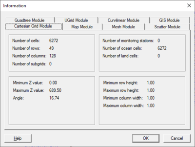
Cartesian Grid Module Information
The following information is shown on the Cartesian Grid Module tab of the Information dialog:
- Number of cells
- Number of rows
- Number of columns
- Minimum Z value
- Maximum Z value
- Angle
- Cell size
- Number of monitoring stations
- Number of ocean cells
- Number of land cells
GIS Module Information
The following information is shown on the GIS Module tab of the Information dialog:
- Number of images
- Number of DEMs
- GIS selector dropdown
- Type
- Global Min
- Global Max
- Data min
- Data max
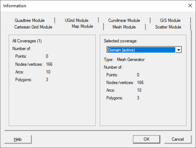
Map Module Information
The following information is shown on the Map Module tab of the Information dialog:
- For all coverages:
- Number of points
- Number of nodes / vertices
- Number of arcs
- Number of polygons
- For selected coverage:
- The drop down menu will list all available coverages. Select a coverage to view information.
- The type of the current coverage
- Number of points
- Number of nodes / vertices
- Number of arcs
- Number of polygons
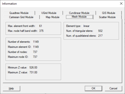
Mesh Module Information
The following information is shown on the Mesh Module tab of the Information dialog:
- Maximum element front width
- Maximum node half band width
- Number of elements
- Maximum element ID
- Number of nodes
- Maximum node ID
- Minimum Z value
- Maximum Z value
- Element type
- Number of triangular elements
- Number of quadrilateral elements
- Model specific Info
- RMA2
- Transition elements
- Junction elements
- Control elements
- Linear elements
- 1D nodes without 1D
- FESWMS
- Number of culverts
- Number of piers
- Number of weirs
- Number of drop inlets
- Max ceiling value
- Min ceiling value
- Generic Mesh Model
- Model name
- RMA2
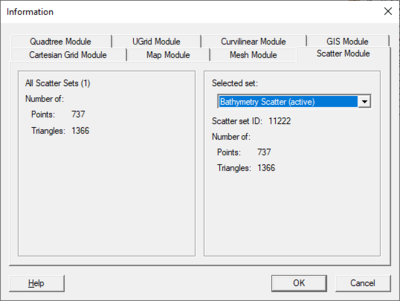
Scatter Module Information
The following information is shown on the Scatter Module tab of the Information dialog:
- For all scatter sets
- Number of points
- Number of triangles
- For selected scatter sets
- The drop down menu will list all available scatter sets. Select a scatter set to view information.
- Scatter set ID
- Number of points
- Number of triangles
UGrid Module Information
The following information is shown on the UGrid Module tab of the Information dialog:
- Number of cells
- Maximum cell id
- Number of points
- Maximum point id
- Minimum Z value
- Maximum Z value
- Element type
- Num. of triangular cells
- Num. of quadrilateral cells
- Constraint type
- Origin X
- Origin Y
- Angle
Related Topics
SMS – Surface-water Modeling System | ||
|---|---|---|
| Modules: | 1D Grid • Cartesian Grid • Curvilinear Grid • GIS • Map • Mesh • Particle • Quadtree • Raster • Scatter • UGrid |  |
| General Models: | 3D Structure • FVCOM • Generic • PTM | |
| Coastal Models: | ADCIRC • BOUSS-2D • CGWAVE • CMS-Flow • CMS-Wave • GenCade • STWAVE • WAM | |
| Riverine/Estuarine Models: | AdH • HEC-RAS • HYDRO AS-2D • RMA2 • RMA4 • SRH-2D • TUFLOW • TUFLOW FV | |
| Aquaveo • SMS Tutorials • SMS Workflows | ||


