SMS:Data Toolbar: Difference between revisions
From XMS Wiki
Jump to navigationJump to search
No edit summary |
No edit summary |
||
| Line 2: | Line 2: | ||
{| class="wikitable" | {| class="wikitable" | ||
! Tool !! width ="125"| Tool Name !! Description | ! Tool !! width ="125"| Tool Name !!width ="325"| Description | ||
|- | |- | ||
| align = "center" | [[Image:Measure_tool.bmp|20 px]] | | align = "center" | [[Image:Measure_tool.bmp|20 px]] | ||
Revision as of 14:39, 21 September 2015
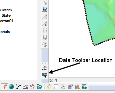
The Data Toolbar contain tools to query or obtain data. Whether the toolbar appears at startup is set in the Preferences dialog. The following tools are available:
| Tool | Tool Name | Description |
|---|---|---|
| File:Measure tool.bmp | Measure Tool | The Measure Tool is used to measure distances interactively. The units used to report the measured distance is specified on the Toolbars tab of the Preferences dialog. |
| File:Get data tool.bmp | Get Data Tool | The Get Data Tool is used to specify the location of interest for obtaining data using the import from web feature. |
Related Topics
SMS Toolbars | |
|---|---|
| Standard Toolbars: | Data • Macros (Display, File, Optional Macro) • Module Toolbar • Static Tools |
| Dynamic Tools | 1D Grid • 2D Mesh Module • Annotations • Cartesian Grid Module • Curvilinear Grid • GIS Module • Map Module • Particle Module • Quadtree • Scatter Module |
| Quick Tour • Layout | |
SMS – Surface-water Modeling System | ||
|---|---|---|
| Modules: | 1D Grid • Cartesian Grid • Curvilinear Grid • GIS • Map • Mesh • Particle • Quadtree • Raster • Scatter • UGrid |  |
| General Models: | 3D Structure • FVCOM • Generic • PTM | |
| Coastal Models: | ADCIRC • BOUSS-2D • CGWAVE • CMS-Flow • CMS-Wave • GenCade • STWAVE • WAM | |
| Riverine/Estuarine Models: | AdH • HEC-RAS • HYDRO AS-2D • RMA2 • RMA4 • SRH-2D • TUFLOW • TUFLOW FV | |
| Aquaveo • SMS Tutorials • SMS Workflows | ||
