|
|
| (18 intermediate revisions by 5 users not shown) |
| Line 1: |
Line 1: |
| {{3D Grid links}} | | {{3D Grid links}} |
| === Creating 3D Grids ===
| | GMS provides two methods for creating 3D grids and multiple ways to edit a 3D grid. |
| Two techniques are available for creating 3D grids: the '''''Create Grid''''' command in the 3D Grid Module and the '''''Map -> 3D Grid''''' command in the Map Module. When a 3D Cell Centered Grid is created two different viewing modes are available. | | == Creating 3D Grids == |
| =====Create Grid=====
| | Two techniques are available for creating 3D grids: the '''Create Grid''' command in the 3D Grid Module and the '''Map → 3D Grid''' command in the Map Module. When a 3D Cell Centered Grid is created two different viewing modes are available. |
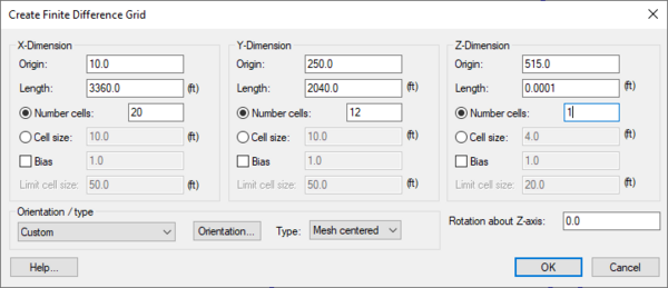
| :A new grid can be created by selecting the '''''Create Grid''''' command from the ''Grid'' menu. This command brings up the Create Grid dialog. The options in the dialog are as follows: | | ===Create Grid=== |
| | {{for|how to create 2D Grids|GMS:2D Grid Creation and Editing#Create Grid}} |
| | {{Create Finite Difference Grid dialog}} |
|
| |
|
| :'''Origin, Length, Rotation''' - By default, the rows and columns of [[GMS:2D Grid Module|2D grids]] are aligned with the x and y axes. However, grids can be rotated about the z-axis, if desired. Thus, the information needed to determine the overall size and location of the grid is the xy coordinates of the lower left corner of the grid (the lower left corner prior to rotation), the length of the grid in the x and y directions, and the rotation angle. The xy coordinates of the origin are entered in the Origin edit fields, the dimensions are entered in the Length fields, and the angle of rotation is entered in the field entitled Rotation about Z-axis. | | ===Map → 3D Grid=== |
| | :Once the feature object coverages defining a conceptual model have been completely defined, the conceptual model is ready to be converted to a numerical model. The first step in this conversion process is to create a grid using the '''Map → 3D Grid''' command. Typically, the [[GMS:Grid Frame|'''Grid Frame''']] command is used prior to this command to define the location and dimensions of the grid. |
|
| |
|
| :'''Bias''' - Several options are available for defining the number and locations of the cell boundaries. A bias can be defined which controls how the cell size varies from one cell to the next. For example, an X bias of 1.5 causes each cell to be 50% larger than the previous cell when moving in the positive x direction. | | :When the '''Map → 3D Grid''' command is selected, the ''Create Grid'' dialog appears. If a grid frame has been defined, the size and location of the grid frame are used to initialize the fields in the ''Create Grid'' dialog. In most cases, these values will not need to be changed and the user can simply select the '''OK''' button to create the grid. If a grid frame has not been defined, the size and location of the grid are initialized so that the grid just surrounds the currently defined conceptual model. Once again, in most cases, no changes will need to be made and the user can typically immediately select the '''OK''' button to create the grid. |
|
| |
|
| :'''Number of Cells''' - The total number of cells in each direction (number of rows or columns) can be defined by explicitly entering a number or by entering a base cell size and a limit cell size. The base and limit cell size options are used when a bias other than 1.0 is specified. The base cell size is the size of the first cell in the sequence. The cells are then generated by altering the cell size according to the bias until the limit cell size is reached. The remainder of the cells are constructed using the limit cell size. | | :If one or more refine points are defined in the conceptual model (available when "Refinement" is selected in the [[GMS:Coverages#Coverage_Setup|Coverage Setup]] dialog), the number of rows and columns in the grid will be automatically determined when the grid is created. Thus, these fields cannot be edited by the user and will be dimmed. If refine points are not defined, the number of rows and columns must be entered. |
|
| |
|
| :'''Type and Orientation''' - The controls at the bottom of the Create Grid dialog are used to define the type and orientation of the grid. The user can specify whether the grid should be a mesh-centered grid or a cell-centered grid. The orientation of the ij axes with respect to the XY axes can also be specified. | | :When refine points are specified the user must enter the ''Base size'', ''Bias'' and ''Max size''. The ''base size'' is the size the user wants the cell to be right at the refine point. The ''Max size'' is the largest size that the user would like the cells to be in the entire grid. The ''bias'' determines how quickly the cell size will vary as they move away from the refine point. If using a bias of 1.1 then the row next to the refine point will be 1.1 times the ''base size''. The next row will be 1.1 size the previous row. |
|
| |
|
| =====Map -> 3D Grid=====
| | == Editing 3D Grids == |
| :Once the feature object coverages defining a conceptual model have been completely defined, the conceptual model is ready to be converted to a numerical model. The first step in this conversion process is to create a grid using the '''''Map -> 3D Grid''''' command. Typically, the [[GMS:Grid Frame|'''''Grid Frame''''']] command is used prior to this command to define the location and dimensions of the grid.
| |
| | |
| :When the '''''Map -> 3D Grid''''' command is selected, the Create Grid dialog appears. If a grid frame has been defined, the size and location of the grid frame are used to initialize the fields in the Create Grid dialog. In most cases, these values will not need to be changed and the user can simply select the OK button to create the grid. If a grid frame has not been defined, the size and location of the grid are initialized so that the grid just surrounds the currently defined conceptual model. Once again, in most cases, no changes will need to be made and the user can typically immediately select the OK button to create the grid.
| |
| | |
| :If one or more refine points are defined in the conceptual model, the number of rows and columns in the grid will be automatically determined when the grid is created. Thus, these fields cannot be edited by the user and will be dimmed. If refine points are not defined, the number of rows and columns must be entered.
| |
| | |
| :When refine points are specified you must enter the Base size, Bias and Max size. The base size is the size you want the cell to be right at the refine point. The Max size is the largest size that you would like your cells to be in the entire grid. The bias determines how quickly the cell size will vary as you move away from the refine point. If you use a bias of 1.1 then the row next to the refine point will be 1.1 times the base size. The next row will be 1.1 size the previous row.
| |
| | |
| === Editing 3D Grids ===
| |
| Each cell in a 3D grid has attributes associated with it. Each grid cell can be specified as [[GMS:Active/Inactive Cells|active/inactive]] and each cell has a [[GMS:Materials|material]] associated with it. To edit the cell attributes associated with a numerical model see [[GMS:Cell Properties|Cell Properties]]. | | Each cell in a 3D grid has attributes associated with it. Each grid cell can be specified as [[GMS:Active/Inactive Cells|active/inactive]] and each cell has a [[GMS:Materials|material]] associated with it. To edit the cell attributes associated with a numerical model see [[GMS:Cell Properties|Cell Properties]]. |
|
| |
|
| Rows, columns, or layers can be added or removed from a 3D grid. A row, column, or layer may be added to the grid by using one of the following tools found in the [[GMS:3D Grid Tool Palette|3D Grid Tool Palette]]: | | Rows, columns, or layers can be added or removed from a 3D grid. A row, column, or layer may be added to the grid by using one of the following tools found in the [[GMS:3D Grid Tool Palette|3D Grid Tool Palette]]: |
|
| |
|
| *[[Image:Tool_AddIRow.GIF]] Add i Boundary | | *[[File:Add I Boundary Tool.svg|16 px]] '''Add i Boundary''' |
|
| |
|
| *[[Image:Tool_AddJRow.GIF]] Add j Boundary | | *[[File:Add J Boundary Tool.svg|16 px]] '''Add j Boundary''' |
|
| |
|
| *[[Image:Tool_AddKRow.GIF]] Add k Boundary | | *[[File:Add K Boundary Tool.svg|16 px]] '''Add k Boundary''' |
|
| |
|
| The boundary of a cell can also be moved to a new location by using the [[GMS:3D Grid Tool Palette|Move Boundary]] tool. Existing rows, columns, or layers can be deleted by using the '''''Merge Selected''''' command in the Grid menu which is used to merge two or more selected rows, columns, or layers into a single row, column, or layer. Since the dimensions of the grid are changed, this command causes all data sets to be deleted. However, MODFLOW input parameters are preserved. | | The boundary of a cell can also be moved to a new location by using the [[GMS:3D Grid Tool Palette|'''Select Node''']] tool. Existing rows, columns, or layers can be deleted by using the '''Merge Selected''' command in the ''Grid'' menu which is used to merge two or more selected rows, columns, or layers into a single row, column, or layer. Since the dimensions of the grid are changed, this command causes all datasets to be deleted. However, MODFLOW input parameters are preserved. |
|
| |
|
| === Exporting 3D Grid Data Sets to a Shapefile===
| |
| To export a 3D Grid data set (for example, a MODFLOW head data set) to a shapefile requires the user to follow a series of commands to convert the data set to a form that can be exported as a shapefile from GMS. The steps are detailed below:
| |
| # With the correct 3D Grid data set selected, use the '''''Convert->2D Grid''''' command in the Grid menu to convert the 3D Grid to a 2D Grid.
| |
| # Use the '''''3D Data->2D Data''''' command in the Data menu to convert the data set from a 3D data set to a 2D data set.
| |
| # Use the '''''Grid->2D Scatter Points''''' command in the Grid menu to convert the 2D Grid data set to a 2D scatter data set.
| |
| # Right click on the newly-created scatter set and select '''Export'''. Change the file type to shapefile.
| |
|
| |
|
| {{Navbox GMS}} | | {{Navbox GMS}} |
| [[Category:3D Grid]] | | [[Category:3D Grid]] |
| | [[Category:3D Grid Dialogs]] |

