SMS:3D Cartesian Grid Module: Difference between revisions
No edit summary |
|||
| (7 intermediate revisions by the same user not shown) | |||
| Line 1: | Line 1: | ||
__NOINDEX__ | |||
{{Not Released}} | |||
This module is currently being developed for future interfaces. | This module is currently being developed for future interfaces. | ||
The 3D Cartesian Grid Module allows the creation of 3D grids which can be used for surface-water modeling. Currently there are no models that use this module. | |||
==3D Grid Types== | |||
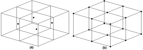
Two types of 3D grids are supported in SMS: cell centered and mesh centered. When computations are performed on a mesh-centered grid, the computation points are the grid nodes or the corners of the grid cells. With a cell-centered grid, computations are performed at the cell centers. | |||
When a dataset is imported to a cell-centered grid, there is one value in the dataset for each cell. To use contouring or fringing the values at the cell corners must be known. Therefore, whenever contouring or fringing is performed, the values at the cell centers are interpolated to the cell corners. Interpolation to cell corners is only done for visualization. All computations performed using the [[SMS:Data Calculator|Data Calculator]] are performed on the original values at the cell centers. With mesh-centered grids, all visualization and computations are performed at the cell corners and no interpolation is necessary. | |||
All of the model interfaces in the 3D Grid module are based on cell-centered grids. Mesh-centered grids are useful for interpolation and isosurface visualization since no extra interpolation is necessary. | |||
:[[Image:GridType2.png|thumb|none|500 px|''(a) Cell Centered Grid (b) Mesh Centered Grid'']] | |||
==3D Cartesian Grid Module Tools== | ==3D Cartesian Grid Module Tools== | ||
| Line 12: | Line 24: | ||
* Create Cell String | * Create Cell String | ||
* Create Cartesian Grid | * Create Cartesian Grid | ||
* Add Contour Label | |||
== Related Topics == | == Related Topics == | ||
| Line 22: | Line 35: | ||
[[Category:SMS 3D Cartesian Grid|3D Cartesian Grid]] | [[Category:SMS 3D Cartesian Grid|3D Cartesian Grid]] | ||
[[Category:Upcoming feature]] | [[Category:Upcoming feature]] | ||
[[Category:Archived]] | |||
Latest revision as of 14:21, 10 June 2019
| This article is for a model that is under development by Aquaveo and its partners. The model is not available to the public at this time. It is not known when or if the model will be released. The content may not apply to current or older versions. |
This module is currently being developed for future interfaces.
The 3D Cartesian Grid Module allows the creation of 3D grids which can be used for surface-water modeling. Currently there are no models that use this module.
3D Grid Types
Two types of 3D grids are supported in SMS: cell centered and mesh centered. When computations are performed on a mesh-centered grid, the computation points are the grid nodes or the corners of the grid cells. With a cell-centered grid, computations are performed at the cell centers.
When a dataset is imported to a cell-centered grid, there is one value in the dataset for each cell. To use contouring or fringing the values at the cell corners must be known. Therefore, whenever contouring or fringing is performed, the values at the cell centers are interpolated to the cell corners. Interpolation to cell corners is only done for visualization. All computations performed using the Data Calculator are performed on the original values at the cell centers. With mesh-centered grids, all visualization and computations are performed at the cell corners and no interpolation is necessary.
All of the model interfaces in the 3D Grid module are based on cell-centered grids. Mesh-centered grids are useful for interpolation and isosurface visualization since no extra interpolation is necessary.
3D Cartesian Grid Module Tools
- Select Grid Cell
- Select Grid Row
- Select Grid Column
- Split Grid Column
- Split Grid Row
- Drag Column Boundary
- Drag Row Boundary
- Select Cell String
- Create Cell String
- Create Cartesian Grid
- Add Contour Label
Related Topics
SMS – Surface-water Modeling System | ||
|---|---|---|
| Modules: | 1D Grid • Cartesian Grid • Curvilinear Grid • GIS • Map • Mesh • Particle • Quadtree • Raster • Scatter • UGrid |  |
| General Models: | 3D Structure • FVCOM • Generic • PTM | |
| Coastal Models: | ADCIRC • BOUSS-2D • CGWAVE • CMS-Flow • CMS-Wave • GenCade • STWAVE • WAM | |
| Riverine/Estuarine Models: | AdH • HEC-RAS • HYDRO AS-2D • RMA2 • RMA4 • SRH-2D • TUFLOW • TUFLOW FV | |
| Aquaveo • SMS Tutorials • SMS Workflows | ||
