AHGW:Add Borehole Image Wizard: Difference between revisions
From XMS Wiki
Jump to navigationJump to search
No edit summary |
No edit summary |
||
| Line 23: | Line 23: | ||
{{-}} | {{-}} | ||
==Image Register == | ==Image Register == | ||
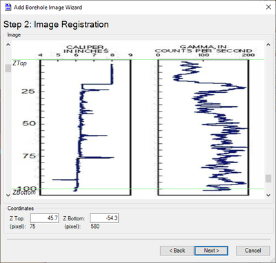
[[File:AHGW-CreateBoreholeImageWizard2.png|thumb| | [[File:AHGW-CreateBoreholeImageWizard2.png|thumb|400 px|Step 2 of the ''Add Borehole Image Wizard'']] | ||
The following sections, options, and fields are available: | The following sections, options, and fields are available: | ||
*''Image'' section – Displays the image selected on the [[#Cross Section Setup|first page]] of the dialog. The scroll buttons on the left and right sides allow the ''ZTop'' and "ZBottom" (respectively) to be manually changed. This affects the width of the resulting plot. The "(pixel)" fields in the ''Coordinates'' section change as the scroll buttons are adjusted. | *''Image'' section – Displays the image selected on the [[#Cross Section Setup|first page]] of the dialog. The scroll buttons on the left and right sides allow the ''ZTop'' and "ZBottom" (respectively) to be manually changed. This affects the width of the resulting plot. The "(pixel)" fields in the ''Coordinates'' section change as the scroll buttons are adjusted. | ||
| Line 34: | Line 34: | ||
{{-}} | {{-}} | ||
==Image Positioning == | ==Image Positioning == | ||
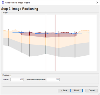
[[File:AHGW-CreateBoreholeImageWizard3.png|thumb| | [[File:AHGW-CreateBoreholeImageWizard3.png|thumb|400 px|Step 3 of the ''Add Borehole Image Wizard'']] | ||
The following sections, options, and fields are available: | The following sections, options, and fields are available: | ||
*''Image'' section – Displays a cross section view of the section line. | *''Image'' section – Displays a cross section view of the section line. | ||
Revision as of 22:15, 7 November 2019
The Add Borehole Image Wizard dialog is accessed by clicking ![]() Select Features, selecting the desired well, clicking
Select Features, selecting the desired well, clicking ![]() Add Borehole Image Wizard on the Arc Hydro Groundwater Toolbar, and then selecting the desired section line. This tool helps register a digital borehole image for use in building 2D cross sections in ArcGIS.
Add Borehole Image Wizard on the Arc Hydro Groundwater Toolbar, and then selecting the desired section line. This tool helps register a digital borehole image for use in building 2D cross sections in ArcGIS.
The dialog contains the following pages:
- Step 1: Cross Section Setup
- Step 2: Image Register
- Step 3: Image Positioning
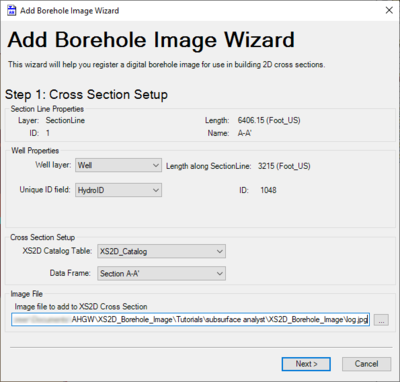
Cross Section Setup
The following sections, options, and fields are available:
- Section Line Properties section – Not user editable. Lists attributes of the selected section line.
- Well Properties section – The left side contains two drop-downs, while the right side indicates the well's location along the section line and the WellID.
- Well layer – Select the name of the well layer from the drop-down.
- Unique ID field *ndash; Select the name of the field to use as the unique ID field.
- Cross Section Setup section
- XS2D Catalog Table – Select the name of the XS2D catalog table from the drop-down.
- Data Frame – Select the desired data frame.
- Image File section
- Next – Switches to the second page of the Add Borehole Image Wizard dialog.
- Cancel – Cancels any changes and exits the Add Borehole Image Wizard dialog.
Image Register
The following sections, options, and fields are available:
- Image section – Displays the image selected on the first page of the dialog. The scroll buttons on the left and right sides allow the ZTop and "ZBottom" (respectively) to be manually changed. This affects the width of the resulting plot. The "(pixel)" fields in the Coordinates section change as the scroll buttons are adjusted.
- Coordinates section
- Z Top – Enter a decimal number for the Z magnification. This number must be greater than the value of Z Bottom.
- Z Bottom – Enter a decimal number for the Z magnification.
- Back – Switches to the first page of the Add Borehole Image Wizard dialog.
- Next – Switches to the third page of the Add Borehole Image Wizard dialog.
- Cancel – Cancels any changes and exits the Add Borehole Image Wizard dialog.
Image Positioning
The following sections, options, and fields are available:
- Image section – Displays a cross section view of the section line.
- Positioning section
- Offset – Decimal value. Size of the offset (if any) from the left side of the image.
- Plot width in map units – Decimal value. A value indicating the width of the plot in map units (e.g., meters, feet).
- Back – Switches to the second page of the Add Borehole Image Wizard dialog.
- Finish – Saves any changes and exits the Add Borehole Image Wizard dialog.
- Cancel – Cancels any changes and exits the Add Borehole Image Wizard dialog.


