GMS:2D Scatter Point Module: Difference between revisions
From XMS Wiki
Jump to navigationJump to search
No edit summary |
No edit summary |
||
| Line 4: | Line 4: | ||
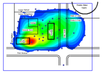
Interpolation is useful for setting up input data for analysis codes and for site characterization. The two figures below show examples of using interpolation. | Interpolation is useful for setting up input data for analysis codes and for site characterization. The two figures below show examples of using interpolation. | ||
[[Image:Sample_LayInterp.gif| | {| | ||
|- | |||
[[Image:samp_2dscat.gif| | |[[Image:Sample_LayInterp.gif|thumb|500px|Interpolation of Modflow Layer Elevations to a 3D Grid]] | ||
|- | |||
|[[Image:samp_2dscat.gif|thumb|500px|Sample Interpolation for Site Characterization]] | |||
|} | |||
{{Navbox GMS}} | {{Navbox GMS}} | ||
[[Category:2D Scatter Point]] | [[Category:2D Scatter Point]] | ||
[[Category:Interpolation]] | [[Category:Interpolation]] | ||
