AHGW:Create AHGW Raster Catalog: Difference between revisions
From XMS Wiki
Jump to navigationJump to search
(Created page with "350px|thumb|right|''Create AHGW Raster Catalog'' dialog The ''Create AHGW Raster Catalog'' tool is accessed by double-clicking on "Fi...") |
No edit summary |
||
| Line 2: | Line 2: | ||
The ''Create AHGW Raster Catalog'' tool is accessed by double-clicking on "[[File:ArcGIS Tool icon 10_5.png|16px]] Create AHGW Raster Catalog" under the "[[File:ArcGIS Toolset icon 10_5.png|16px]] Groundwater Analyst" toolset under the "[[File:ArcGIS Toolbox icon 10_5.png|16px]] Arc Hydro Groundwater Tools" toolbox. | The ''Create AHGW Raster Catalog'' tool is accessed by double-clicking on "[[File:ArcGIS Tool icon 10_5.png|16px]] Create AHGW Raster Catalog" under the "[[File:ArcGIS Toolset icon 10_5.png|16px]] Groundwater Analyst" toolset under the "[[File:ArcGIS Toolbox icon 10_5.png|16px]] Arc Hydro Groundwater Tools" toolbox. | ||
The following fields are available. Required fields are marked with a [[File:ArcGIS required - green circle icon.png| | The following fields are available. Required fields are marked with a [[File:ArcGIS required - green circle icon.png|8px]] icon. | ||
*''Input UniqueID Table'' – A drop-down listing types of AHGW raster catalog: | *''Input UniqueID Table'' – A drop-down listing types of AHGW raster catalog: | ||
**"GEORASTERS" – Select to create a GeoRasters catalog. | **"GEORASTERS" – Select to create a GeoRasters catalog. | ||
**"RASTERSERIES" – Select to create a RasterSeries catalog. | **"RASTERSERIES" – Select to create a RasterSeries catalog. | ||
*[[File:ArcGIS required - green circle icon.png| | *[[File:ArcGIS required - green circle icon.png|8px]] ''Spatial Reference'' – Click the [[File:ArcGIS Select from List button 10_5.png|16px]] button to bring up the ''Spatial Reference Properties'' dialog where a spatial reference system can be sleected. | ||
*[[File:ArcGIS required - green circle icon.png| | *[[File:ArcGIS required - green circle icon.png|8px]] ''Output Raster Catalog'' – Click the [[File:ArcGIS Browse button 10_5.png|16px]] button to bring up the ''Output Raster Catalog'' dialog in order to specify the name of the output raster catalog. | ||
{{Navbox AHGW}} | {{Navbox AHGW}} | ||
[[Category:AHGW Groundwater Analyst]] | [[Category:AHGW Groundwater Analyst]] | ||
Revision as of 23:16, 22 August 2019
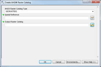
The Create AHGW Raster Catalog tool is accessed by double-clicking on "![]() Create AHGW Raster Catalog" under the "
Create AHGW Raster Catalog" under the "![]() Groundwater Analyst" toolset under the "
Groundwater Analyst" toolset under the "![]() Arc Hydro Groundwater Tools" toolbox.
Arc Hydro Groundwater Tools" toolbox.
The following fields are available. Required fields are marked with a ![]() icon.
icon.
- Input UniqueID Table – A drop-down listing types of AHGW raster catalog:
- "GEORASTERS" – Select to create a GeoRasters catalog.
- "RASTERSERIES" – Select to create a RasterSeries catalog.
 Spatial Reference – Click the
  button to bring up the Spatial Reference Properties dialog where a spatial reference system can be sleected.
 Output Raster Catalog – Click the
  button to bring up the Output Raster Catalog dialog in order to specify the name of the output raster catalog.

