AHGW:Add to Raster Series: Difference between revisions
From XMS Wiki
Jump to navigationJump to search
No edit summary |
m (Added a category) |
||
| Line 16: | Line 16: | ||
{{Navbox AHGW}} | {{Navbox AHGW}} | ||
[[Category:AHGW Groundwater Analyst|Add to Raster Series]] | [[Category:AHGW Groundwater Analyst|Add to Raster Series]] | ||
[[Category:AHGW Dialogs]] | |||
Revision as of 19:20, 26 August 2019
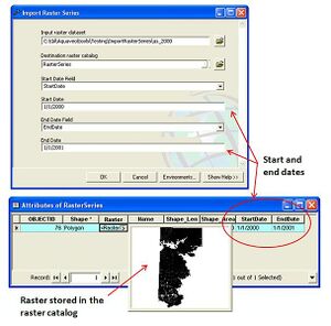
The AHGW Add to Raster Series tool loads a raster dataset into a raster catalog and attributes the raster with a start and end date/time. The start and end date/time represent the time period of the data stored in the raster, and can be used for animating a series of rasters stored in the catalog.
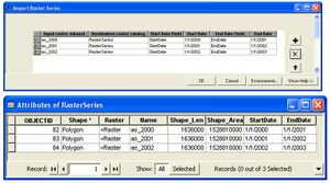
In addition to importing a single raster, the tool has a batch mode for importing a set of rasters into the catalog and attributing them with the appropriate date/time values.
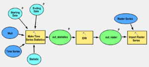
To automate the process of generating a set of raster series from point features and time series data, the tool can be combined in a model with the Make Time Series Statistics tool. The following image shows a model that:
- Creates time series statistics from given points and tabular time series,
- Interpolates the points to a raster, and
- Imports the raster to a raster catalog and attributes the rasters with appropriate date/time values.


