User:Rcorrigan/AHGW Pro:Groundwater Analyst: Difference between revisions
From XMS Wiki
Jump to navigationJump to search
No edit summary |
No edit summary |
||
| Line 2: | Line 2: | ||
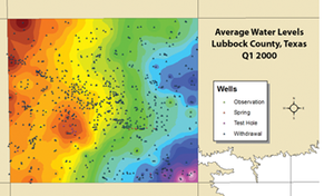
[[File:AHGW Groundwater Analyst example.png|thumb|right|An example of using the groundwater analyst in ArcGIS]] | [[File:AHGW Groundwater Analyst example.png|thumb|right|An example of using the groundwater analyst in ArcGIS]] | ||
Tools in the Groundwater Analyst allow importing of data into an [[AHGW:AHGW|Arc Hydro Groundwater]] (AHGW) data model, managing key attributes, and visualizing the data. Groundwater Analyst facilitates importing a variety of datasets (wells, time series, cross sections, volumes) into a geodatabase, managing symbology of layers in ArcGIS Pro, mapping and plotting time series, and creating common products such as water level, water quality, and flow direction maps. | Tools in the Groundwater Analyst allow importing of data into an [[AHGW:AHGW|Arc Hydro Groundwater]] (AHGW) data model, managing key attributes, and visualizing the data. Groundwater Analyst facilitates importing a variety of datasets (wells, time series, cross sections, volumes) into a geodatabase, managing symbology of layers in ArcGIS Pro, mapping and plotting time series, and creating common products such as water level, water quality, and flow direction maps. | ||
:'''''ArcGIS Notes''''' – The ''Make Time Series Statistics'' tool is not categorized under the ''Groundwater Analyst | Time Series'' toolset in older versions of ArcGIS. It is categorized | :'''''ArcGIS Notes''''' – The ''Make Time Series Statistics'' tool is not categorized under the ''Groundwater Analyst | Time Series'' toolset in older versions of ArcGIS. It is simply categorized under the ''Groundwater Analyst'' toolset. | ||
The Groundwater Analyst toolset include the following tools and toolsets: | The Groundwater Analyst toolset include the following tools and toolsets: | ||
*[[AHGW:Add to Raster Series|Add to Raster Series]] | *[[AHGW:Add to Raster Series|Add to Raster Series]] | ||
| Line 10: | Line 10: | ||
*[[AHGW:Create Unique ID Table|Create Unique ID Table]] | *[[AHGW:Create Unique ID Table|Create Unique ID Table]] | ||
*[[AHGW:Modify AHGW Geodatabase|Modify AHGW Geodatabase]] | *[[AHGW:Modify AHGW Geodatabase|Modify AHGW Geodatabase]] | ||
*Features toolset | *''Features'' toolset | ||
**[[AHGW:Create Well Feature Class|Create Well Feature Class]] | **[[AHGW:Create Well Feature Class|Create Well Feature Class]] | ||
*Time Series toolset | *''Time Series'' toolset | ||
**[[AHGW:Create Time Series Tables|Create Time Series Tables]] | **[[AHGW:Create Time Series Tables|Create Time Series Tables]] | ||
**[[AHGW:Make Time Series Statistics|Make Time Series Statistics]] | **[[AHGW:Make Time Series Statistics|Make Time Series Statistics]] | ||
Revision as of 18:06, 1 September 2022
Tools in the Groundwater Analyst allow importing of data into an Arc Hydro Groundwater (AHGW) data model, managing key attributes, and visualizing the data. Groundwater Analyst facilitates importing a variety of datasets (wells, time series, cross sections, volumes) into a geodatabase, managing symbology of layers in ArcGIS Pro, mapping and plotting time series, and creating common products such as water level, water quality, and flow direction maps.
- ArcGIS Notes – The Make Time Series Statistics tool is not categorized under the Groundwater Analyst | Time Series toolset in older versions of ArcGIS. It is simply categorized under the Groundwater Analyst toolset.
The Groundwater Analyst toolset include the following tools and toolsets:
- Add to Raster Series
- Assign HydroID GW
- Create AHGW Raster Catalog
- Create Blank AHGW Geodatabase
- Create Unique ID Table
- Modify AHGW Geodatabase
- Features toolset
- Time Series toolset
See Also

