GMS:2D Grid Module: Difference between revisions
From XMS Wiki
Jump to navigationJump to search
No edit summary |
No edit summary |
||
| Line 2: | Line 2: | ||
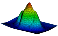
The 2D Grid module is used for creating and editing two-dimensional Cartesian grids. 2D grids are primarily used for surface visualization and [[GMS:Contour Options|contouring]]. This is accomplished by [[GMS:Interpolation|interpolating]] to the grid. The figure below is an example of interpolating contaminant concentration data to a 2D grid. | The 2D Grid module is used for creating and editing two-dimensional Cartesian grids. 2D grids are primarily used for surface visualization and [[GMS:Contour Options|contouring]]. This is accomplished by [[GMS:Interpolation|interpolating]] to the grid. The figure below is an example of interpolating contaminant concentration data to a 2D grid. | ||
[[Image:grid_interp.gif| | {| | ||
|- | |||
[[Image:Sample_water_table.GIF| | |[[Image:grid_interp.gif|thumb|500 px|Concentration Data Interpolated to a 2D Grid]] | ||
|- | |||
|[[Image:Sample_water_table.GIF|thumb|500 px|Watertable Elevations From a MODFLOW Simulation]] | |||
|} | |||
==See also== | ==See also== | ||
