AHGW:Make Time Series Statistics
From XMS Wiki
Jump to navigationJump to search
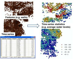
The Make Time Series Statistics tool creates mappable layers of time series by joining spatial features (points, lines, polygons) with time series data (e.g., water levels, concentrations). The output is a new feature class containing features with summary statistics (e.g. mean, max, min) of the related time series over a given time period.
File:AHGW Make Time Series Statistics dialog - old.jpg
Make Time Series Statistics dialog
Implementation
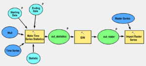
The tool can be linked with interpolation tools and with the Import Raster Series tool to automate the process of interpolating surfaces for given time periods. For example, the tool can be used to produce monthly/daily water level surfaces.


