Search results
From XMS Wiki
Jump to navigationJump to search
- ...selecting the HY-8 modeling wizard tool in the [[WMS:Get Data Toolbar|Get Data Toolbar]] ([[Image:GetDataToolbar1.png]]). # [[WMS:Watershed Data|Watershed Data]]2 KB (316 words) - 16:38, 27 February 2018
- ...a from parent model'' – Select to output the computed watershed mask data from the parent model. ...h; Turn on to have WMS update the child model with computed watershed mask data from the current project.3 KB (561 words) - 21:29, 15 May 2019
- ;3. Elevation, Watershed, and Grid Changes :[[WMS:MWBM Wizard#Elevation Data|Elevation Data]]1 KB (171 words) - 19:12, 22 March 2019
- ...(outlets), lines (streams), and polygons (boundaries) for more convenient data storage and manipulation. [[WMS:Quick Tour - Feature Object Data| '''< Previous''']] | [[WMS:Quick Tour - Conceptual Model for Creating a468 bytes (66 words) - 15:50, 11 April 2017
- GIS data is especially useful in WMS for delineating watersheds and computing Orange ...automated when digitial terrain data (DEMs or TINs) exists within WMS. GIS data may be used to identify geometric features such as sub-area boundaries, str2 KB (313 words) - 15:11, 16 October 2017
- ...a resolution of 30-meters for the entire U.S. and some 90-meter world-wide data is also available. [[WMS:Quick Tour - Terrain Data| '''< Previous''']] | [[WMS:Quick Tour - Flow Direction Vectors| ''' Next625 bytes (88 words) - 21:07, 3 February 2023
- [[File:TR-55 Outlets.png|thumb|250 px|The ''TR-55'' dialog showing outlet data]] WMS allows defining the watershed as a single basin or subdivide the watershed into multiple sub-basins. Besides computing peak flows using the standard T2 KB (262 words) - 16:40, 19 December 2017
- [[WMS:MWBM Wizard#Delineate Watershed|Delineate Watershed]] · [[WMS:MWBM Wizard#Elevation Data|Elevation Data]] ·790 bytes (91 words) - 19:21, 22 March 2019
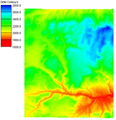
File:WMS DEMexampleQuick.jpg ...a resolution of 30-meters for the entire U.S. and some 90-meter world-wide data is also available.(443 × 459 (45 KB)) - 16:56, 5 January 2017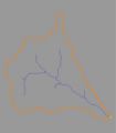
File:Fobj.jpg ...imes the simplest solution to creating a watershed model is to use the GIS data directly to delineate boundaries.(350 × 400 (8 KB)) - 16:22, 9 January 2017- :''C<sub>t</sub>'' = coefficient of watershed topography based on impervious area. :''I<sub>a</sub>'' = percentage of impervious area in the watershed (must be defined in the HEC-1 Loss methods).1 KB (201 words) - 15:11, 29 September 2017
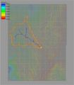
File:Demtofobj.jpg ...(outlets), lines (streams), and polygons (boundaries) for more convenient data storage and manipulation.(350 × 400 (56 KB)) - 15:39, 9 January 2017- A primary use of WMS is to automatically delineate watershed, stream, and sub-basin boundaries from digital elevation sources such as TI ...thod is simpler and more repeatable because of the uniform nature of a DEM data structure. When inadequate elevation resolution is available (i.e. many urb3 KB (430 words) - 20:33, 17 December 2019
- ...ermits users to take advantage of many of ArcGIS tools as they construct a watershed model, including: ...uick Tour - GIS Data| '''< Previous''']] | [[WMS:Quick Tour - Adding GIS Data without ArcObjects| ''' Next >''']]836 bytes (122 words) - 15:52, 11 April 2017
- :''T<sub>LAG</sub>'' = watershed lag time in hours. :''L'' = watershed maximum flow distance length in miles.1 KB (236 words) - 15:16, 29 September 2017
- ...tion|Outlet Location]]{{·}}[[WMS:MWBM Wizard#Delineate Watershed|Delineate Watershed]]{{·}}[[WMS:MWBM Wizard#Create 2D Grid|Create 2D Grid]]{{·}}[[WMS:MWBM Wi1 KB (152 words) - 19:23, 22 March 2019
- ...shed model for hydrologic analysis or as a companion in the development of watershed models with TINs and DEMs. ...can be created automatically from points, lines, and polygons. Since these data are often already developed and stored in a GIS, importing from [[WMS:Impor4 KB (742 words) - 16:00, 26 October 2017
- ...t common and simplest methods available for automatically characterizing a watershed. Many raster GIS programs have similar capabilities, but WMS has been desig #Identify the watershed outlet and covert DEM streams to arcs.2 KB (251 words) - 21:52, 17 December 2019
- ...d models. This data is termed "Map data" in WMS. Based on its purpose, Map data is grouped together into Coverages. Some of the most common Coverage types ...ion (Flow Paths)| '''< Previous''']] | [[WMS:Quick Tour - Feature Object Data| ''' Next >''']]758 bytes (114 words) - 15:50, 11 April 2017
- ...del'' step is used for defining which model is running with the delineated watershed. ...this button to set the model to the selected option, initialize the model data to default values, and set the module to the correct module.561 bytes (78 words) - 15:19, 20 October 2017


