SMS:Data Toolbar
From XMS Wiki
Jump to navigationJump to search
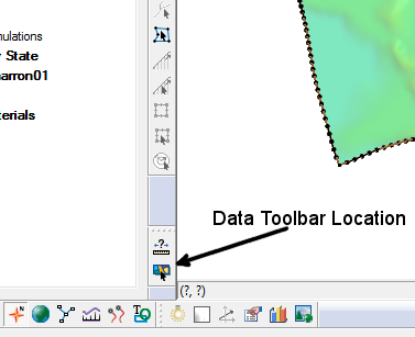
The Data Toolbar contain tools to query or obtain data. Whether the toolbar appears at startup is set in the Preferences dialog. The following tools are available:
Measure Tool
The Measure Tool File:Measure tool.png is used to measure distances interactively. When clicking in the graphics window, a line will show the distance being measured and the Coordinates Bar will show the total numerical value. The units used to report the measured distance is specified on the Toolbars tab of the Preferences dialog.
Get Data Tool
The Get Data Tool File:Get data tool.bmp is used to specify the location of interest for obtaining data using the import from web feature. Click and drag in the main graphics window to specify the area to be downloaded.
Related Topics
SMS Toolbars | |
|---|---|
| Standard Toolbars: | Data • Macros (Display, File, Optional Macro) • Module Toolbar • Static Tools |
| Dynamic Tools | 1D Grid • 2D Mesh Module • Annotations • Cartesian Grid Module • Curvilinear Grid • GIS Module • Map Module • Particle Module • Quadtree • Scatter Module |
| Quick Tour • Layout | |
SMS – Surface-water Modeling System | ||
|---|---|---|
| Modules: | 1D Grid • Cartesian Grid • Curvilinear Grid • GIS • Map • Mesh • Particle • Quadtree • Raster • Scatter • UGrid |  |
| General Models: | 3D Structure • FVCOM • Generic • PTM | |
| Coastal Models: | ADCIRC • BOUSS-2D • CGWAVE • CMS-Flow • CMS-Wave • GenCade • STWAVE • WAM | |
| Riverine/Estuarine Models: | AdH • HEC-RAS • HYDRO AS-2D • RMA2 • RMA4 • SRH-2D • TUFLOW • TUFLOW FV | |
| Aquaveo • SMS Tutorials • SMS Workflows | ||
