User:Rcorrigan/AHGW:Create AHGW Raster Catalog Pro
From XMS Wiki
Jump to navigationJump to search
The Create AHGW Raster Catalog tool is accessed by double-clicking on "![]() Create AHGW Raster Catalog" under the "
Create AHGW Raster Catalog" under the "![]() Groundwater Analyst" toolset under the "
Groundwater Analyst" toolset under the "![]() ArcHydroGroundwater.pyt" toolbox.
ArcHydroGroundwater.pyt" toolbox.
- ArcGIS Note – In older versions of ArcGIS, this tool appears as a dialog and is accessed through the "Arc Hydro Groundwater Tools" toolbox. In ArcGIS, there are raster catalogs. Raster catalogs were replaced by mosaic datasets in ArcGIS Pro. The icons also vary between ArcGIS and ArcGIS Pro.
The following fields are available. Required fields are maked with a ![]() icon. In ArcGIS, they are marked with a
icon. In ArcGIS, they are marked with a ![]() icon.
icon.
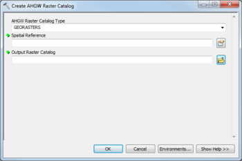
- AHGW Raster Catalog Type – A drop-down listing types of AHGW raster catalog:
- "GEORASTERS" – Select to create a GeoRasters catalog.
- "RASTERSERIES" – Select to create a RasterSeries catalog.
 Spatial Reference – Click the
  button to bring up the Coordinate System dialog where a spatial reference system can be selected.
 Output Raster Catalog – Click the
  button to bring up the Output Raster Catalog dialog in order to specify the name of the output raster catalog.

