GMS:2D Scatter Point Module
From XMS Wiki
The 2D Scatter Point module is used to interpolate from groups of 2D scattered data to other objects (meshes, grids, TINs). Several interpolation schemes are supported, including kriging.
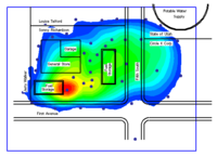
Interpolation is useful for setting up input data for analysis codes and for site characterization. The two figures below show examples of using interpolation.
File:Sample LayInterp.gif
Interpolation of Modflow Layer Elevations to a 3D Grid
File:Samp 2dscat.gif
Sample Interpolation for Site Characterization
| [hide]GMS – Groundwater Modeling System | ||
|---|---|---|
| Modules: | 2D Grid • 2D Mesh • 2D Scatter Point • 3D Grid • 3D Mesh • 3D Scatter Point • Boreholes • GIS • Map • Solid • TINs • UGrids | |
| Models: | FEFLOW • FEMWATER • HydroGeoSphere • MODAEM • MODFLOW • MODPATH • mod-PATH3DU • MT3DMS • MT3D-USGS • PEST • PHT3D • RT3D • SEAM3D • SEAWAT • SEEP2D • T-PROGS • ZONEBUDGET | |
| Aquaveo | ||
Hidden category:
