OceanMesh UGrid Cleaner Tool
OceanMesh UGrid Cleaner
The OceanMesh UGrid Cleaner adjusts an existing mesh through deletion of elements and movement of nodes to fix several common topological and mesh quality issues that would otherwise make numerical simulation with the developed model intractable.
For a valid numerical simulation with most numerical models, the mesh composed of points and triangles (elements) must have the following characteristics:
- The points in each triangle are arranged in a consistent order (e.g., counterclockwise).
- There are no overlapping elements.
- No disjoint or “hanging” points (i.e., points are always part of elements) and points are always shared between neighbouring elements.
- The boundary of the mesh must have only two traversal paths.
In addition, for numerical simulation to be successful, the mesh quality (Bank 1998) must be above a certain minimum threshold. This tool will attempt to delete and move problematic elements to enable numerical simulation. With that said, there are a number of other functionalities inside SMS that can be used to improve mesh quality.
Inputs
- UGrid/Mesh to Clean – the mesh that will be “cleaned” of topological defects in their elements.
- Minimum permitted quality of the boundary elements – elements that are on the boundary of the mesh below this mesh quality will be deleted. These regions along the boundary can be revisited inside SMS.
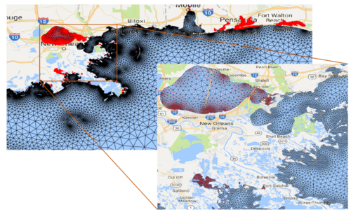
- Minimum percent area of total area to retain a disconnected area – disconnected areas of the mesh below this percent (specified as a decimal) of the total area are decimated from the mesh. For example, in Figure 1, Lake Pontchartrain is not connected to the Gulf of Mexico due to insufficient mesh resolution and would be removed by this tool at this level of model fidelity. Additionally, areas to the east that are also relatively small and disconnected would be decimated.
Outputs
- Topologically cleaned mesh – name of the output mesh/UGrid.
Current Location in Toolbox
Unstructured Grids/OceanMesh UGrid Cleaner
References
- Randolph E. Bank. PLTMG: A Software Package for Solving Elliptic Partial Differential Equations. Society for Industrial and Applied Mathematics, 1 1998. ISBN 978-0-89871-409-8. doi: 10.1137/ 1.9780898719635. URL http://epubs.siam.org/doi/book/10.1137/1.9780898719635.
SMS – Surface-water Modeling System | ||
|---|---|---|
| Modules: | 1D Grid • Cartesian Grid • Curvilinear Grid • GIS • Map • Mesh • Particle • Quadtree • Raster • Scatter • UGrid |  |
| General Models: | 3D Structure • FVCOM • Generic • PTM | |
| Coastal Models: | ADCIRC • BOUSS-2D • CGWAVE • CMS-Flow • CMS-Wave • GenCade • STWAVE • WAM | |
| Riverine/Estuarine Models: | AdH • HEC-RAS • HYDRO AS-2D • RMA2 • RMA4 • SRH-2D • TUFLOW • TUFLOW FV | |
| Aquaveo • SMS Tutorials • SMS Workflows | ||
