SMS:RMA4 Model Control

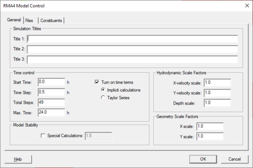
The Model Control Dialog is used to define general, file, and constituents characteristics. The General tab includes options to set up the period of time the model will run, and hydrodynamic and geometry scale factors. The File tab includes the time step used from the RMA2 velocity file and the time subtracted from the RMA2 velocity file, RMA4 Output files options, and Informational Files to be produced when running the model. The Constituents tab includes diffusion coefficient for the constituent, constituent control, and mass check.
General
Simulation Titles. The RMA4 *.geo file contains three comment lines, which can be set using the Title 1, Title 2, and Title 3 edit fields.
Time control
- Start time
- Time Step
- Total Steps
- Max. Time
Model Stability
- Special Calculations
Hydrodynamic Scale Factors
- X-Velocity scale
- Y-Velocity scale
- Depth scale
Geometry Scale Factors
- X scale
- Y scale
Files

RMA4 Input Files – Time steps from the RMA2 solution file that will be used for the RMA4 simulation.
- Last time step used from the RMA2 velocity file
- Time subtracted from the RMA2 velocity file
- Hotstart Input file
- Alternate Dynamic BC File
RMA4 Output files – Output files when running RMA4
- Write Hotstart File
- Write RMA4 Solution File
- Write specific time range
Information Files – Files to create when running RMA4
- Echo card input to screen
- Write ASCII results file
- Suppress initial conditions and detailed geometry
- All input data
- Suppress detailed geometry
- Save nodal results every __ time step
- Subroutine trace
- Debug trace at level
- Write summary by node file
- Write automatically computed parameters file
- Activate full report
Constituents
- Diffusion Coefficient – Diffusion Coefficient Method and Peclet Number Method.
- Constituent Control – Number of constituents, initial concentration for each of the constituents, and decay coefficient for each coefficient.
- Mass Check – Mass conservation check.

Related Topics
| [hide] SMS – Surface-water Modeling System | ||
|---|---|---|
| Modules: | 1D Grid • Cartesian Grid • Curvilinear Grid • GIS • Map • Mesh • Particle • Quadtree • Raster • Scatter • UGrid |  |
| General Models: | 3D Structure • FVCOM • Generic • PTM | |
| Coastal Models: | ADCIRC • BOUSS-2D • CGWAVE • CMS-Flow • CMS-Wave • GenCade • STWAVE • WAM | |
| Riverine/Estuarine Models: | AdH • HEC-RAS • HYDRO AS-2D • RMA2 • RMA4 • SRH-2D • TUFLOW • TUFLOW FV | |
| Aquaveo • SMS Tutorials • SMS Workflows | ||