SMS:TUFLOW Grid Options

The TUFLOW Grid Options dialog (accessed by right-clicking on TUFLOW 2D geometry component ![]() under the TUFLOW components
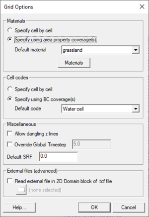
under the TUFLOW components ![]() folder in the Project Explorer and selecting Grid Options) is used to specify how TUFLOW will handle the grid data. Some of the options deal with what types of data will be specified for the grid cells. This data can alternatively be specified using coverages and this has several advantages including size of the data, speed of execution, and more opportunities for reuse.
folder in the Project Explorer and selecting Grid Options) is used to specify how TUFLOW will handle the grid data. Some of the options deal with what types of data will be specified for the grid cells. This data can alternatively be specified using coverages and this has several advantages including size of the data, speed of execution, and more opportunities for reuse.
The general options include:
- Materials
- Specify cell by cell
- Specify using area property coverage(s)
- Default material – Allows selection of the default material for grid cells that have not already been assigned.
- Materials button – Brings up the general Material Data dialog.
- Cell Codes
- Specify cell by cell
- Specify using BC coverage(s)
8* Default code
- Miscellaneous
- Allowing dangling z lines – Turns on/off the TUFLOW command to check for dialing z lines (see the TUFLOW manual for description).
- Override Global Time Step – Since the required time step depends heavily on the size of grid cells, it is often convenient for each grid to have a unique time step when using multiple grids in a simulation. These controls allow overriding the global time step on a grid by grid basis.
- Default SRF
- External Files (Advanced)
- Read External File in TGC file – Can be used to read an external file from the TUFLOW TGC file.
- Read External File in 2D Domain block of TCF file.
The rest of the dialog is used to tell SMS what kind of data to write from the grid in SMS. The optional data types are materials and cell codes. Materials may be specified using an area property coverage and cell codes can be specified from polygons in a TUFLOW Boundary Condition coverage. If a grid (instead of a TUFLOW grid extents coverage) is being used in the 2D geometry command component, these properties can also be specified cell by cell. If using an Area Property coverage, a default material is specified for any areas not inside of a polygon.
Related Topics
| [hide] SMS – Surface-water Modeling System | ||
|---|---|---|
| Modules: | 1D Grid • Cartesian Grid • Curvilinear Grid • GIS • Map • Mesh • Particle • Quadtree • Raster • Scatter • UGrid |  |
| General Models: | 3D Structure • FVCOM • Generic • PTM | |
| Coastal Models: | ADCIRC • BOUSS-2D • CGWAVE • CMS-Flow • CMS-Wave • GenCade • STWAVE • WAM | |
| Riverine/Estuarine Models: | AdH • HEC-RAS • HYDRO AS-2D • RMA2 • RMA4 • SRH-2D • TUFLOW • TUFLOW FV | |
| Aquaveo • SMS Tutorials • SMS Workflows | ||