Element Types: Difference between revisions
From XMS Wiki
Jump to navigationJump to search
No edit summary |
(typo) |
||
| (4 intermediate revisions by one other user not shown) | |||
| Line 1: | Line 1: | ||
Element types used in XMS software | Element types used in XMS software. | ||
{| class="wikitable" border="1" | {| class="wikitable" border="1" | ||
| Line 74: | Line 74: | ||
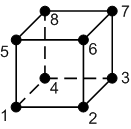
! FaceID !! Node Indices | ! FaceID !! Node Indices | ||
|- | |- | ||
| 1 || 1,4,3, | | 1 || 1,4,3,2 | ||
|- | |- | ||
| 2 || 5,6,7,8 | | 2 || 5,6,7,8 | ||
| Line 110: | Line 110: | ||
{{Navbox GMS}} | {{Navbox GMS}} | ||
{{Navbox SMS}} | {{Navbox SMS}} | ||
[[Category:General Information|E]] | |||
[[Category:2D Mesh]] | |||
Latest revision as of 00:14, 12 December 2017
Element types used in XMS software.
GMS – Groundwater Modeling System | ||
|---|---|---|
| Modules: | 2D Grid • 2D Mesh • 2D Scatter Point • 3D Grid • 3D Mesh • 3D Scatter Point • Boreholes • GIS • Map • Solid • TINs • UGrids | |
| Models: | FEFLOW • FEMWATER • HydroGeoSphere • MODAEM • MODFLOW • MODPATH • mod-PATH3DU • MT3DMS • MT3D-USGS • PEST • PHT3D • RT3D • SEAM3D • SEAWAT • SEEP2D • T-PROGS • ZONEBUDGET | |
| Aquaveo | ||
SMS – Surface-water Modeling System | ||
|---|---|---|
| Modules: | 1D Grid • Cartesian Grid • Curvilinear Grid • GIS • Map • Mesh • Particle • Quadtree • Raster • Scatter • UGrid |  |
| General Models: | 3D Structure • FVCOM • Generic • PTM | |
| Coastal Models: | ADCIRC • BOUSS-2D • CGWAVE • CMS-Flow • CMS-Wave • GenCade • STWAVE • WAM | |
| Riverine/Estuarine Models: | AdH • HEC-RAS • HYDRO AS-2D • RMA2 • RMA4 • SRH-2D • TUFLOW • TUFLOW FV | |
| Aquaveo • SMS Tutorials • SMS Workflows | ||
