AHGW:Create 3D Geophysical Plot Features: Difference between revisions
From XMS Wiki
Jump to navigationJump to search
(Created page with "350px|thumb|right|''Create 3D Geophysical Plot Features'' dialog The ''Create 3D Geophysica...") |
m (Move page script moved page AHGW:Create 3D Geophysical Plot Features to Test:Create 3D Geophysical Plot Features without leaving a redirect) |
Latest revision as of 23:40, 9 September 2019
The Create 3D Geophysical Plot Features tool is accessed by double-clicking on "![]() Create 3D Geophysical Plot Features" under the "
Create 3D Geophysical Plot Features" under the "![]() 3D Import" toolset under the "
3D Import" toolset under the "![]() Subsurface Analyst" toolset under the "
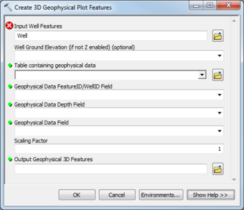
Subsurface Analyst" toolset under the "![]() Arc Hydro Groundwater Tools" toolbox. This tool creates 3D features representing geophysical data for a well. The tool will create circular features at the depth value specified below the well, with a radius equal to the geophysical data value multiplied by the scaling factor. A field containing extrude information can be used when displaying the data in ArcScene.
Arc Hydro Groundwater Tools" toolbox. This tool creates 3D features representing geophysical data for a well. The tool will create circular features at the depth value specified below the well, with a radius equal to the geophysical data value multiplied by the scaling factor. A field containing extrude information can be used when displaying the data in ArcScene.
The following fields are available. Required fields are marked with a ![]() icon. Fields marked with a
icon. Fields marked with a ![]() icon may either not be supported or the table doesn't exist.
icon may either not be supported or the table doesn't exist.
- Input Well Features – Click the
 button to bring up the Input Well Features dialog in order to specify the Well features, which are used as reference points for the geophysical data to plot.
 - Well Ground Elevation – Optional. Select from the drop-down the field in the Well features that specifies the well ground elevation. This should be specified if the Well features are not Z enabled.
 Table containing geophysical data – Click the
  button to bring up the Table containing geophysical data dialog in order to specify the table containing the geophysical data. The table should include a WellID or FeatureID, which points back to the HydroID of the related Well feature, along with fields containing the depth and values for each geophysical data point.
 Geophysical Data FeatureID/WellID Field – Select from the drop-down the field specifying the Unique ID (e.g., HydroID) of the Well features.
 Geophysical Data Depth Field – Select from the drop-down the field containing the depth values for the geophysical data table.
 Geophysical Data Field – Select from the drop-down the field containing the geophysical data values to create 3D features from.
- Scaling Factor – Enter the value to scale the geophysical data values by when creating the 3D geophysical features.
 Output Geophysical 3D Features – Click the
  button to bring up the Output Geophysical 3D Features dialog in order to specify the output feature class where the 3D geophysical features will be created. Make sure it has a valid XY and Z domain for the Z enabled polygon features that will be created.

