SMS:2D Mesh Options Dialog: Difference between revisions
From XMS Wiki
Jump to navigationJump to search
No edit summary |
No edit summary |
||
| (19 intermediate revisions by the same user not shown) | |||
| Line 1: | Line 1: | ||
The Map → 2D Mesh command is used to create a 2D mesh using the feature objects in a 2D Mesh | __NOINDEX__ | ||
{{SMS Deprecated Feature}} | |||
[[Image:2D Mesh Options.jpg|thumb|225 px|''2D Mesh Options'' dialog]] | |||
The '''Map → 2D Mesh''' command is used to create a 2D mesh using the feature objects in a 2D Mesh coverage. When the '''Map → 2D Mesh''' command is selected, the ''2D Mesh Options'' dialog opens. A meshing polygon must have been defined prior to issuing this command. The attributes of the meshing polygon(s) are used to generate the 2D mesh. | |||
The ''2D Mesh Options'' dialog is used to set options for the 2D mesh generation process. The options include: | |||
* ''Delete existing mesh'' – If checked, the existing mesh will be deleted. If not checked, the new mesh will merge with the existing mesh | |||
* ''Merge triangles after meshing'' – If checked, triangular elements created during the mesh generation process will be merged into quadrilateral elements where possible. | |||
* ''Copy coverage before meshing'' – Create a copy of the coverage before the mesh generation algorithm redistributes vertices along the feature arcs defining meshing polygons. Feature arcs are only redistributed when using the [[SMS:Paving#Scalar Paving Density|scalar paving density]] mesh generation method. | |||
* ''Use area coverage'' – This option is only available is at least one [[SMS:Area Property Coverage|Area Property coverage]] exists. These coverages consist of polygons with a material type assigned to each polygon. If this option is checked, the material type specified for the polygon in the source coverage is ignored. Instead, each element is assigned a material type based on the polygon the element centroid lies inside of in the area property coverage. | |||
== Related Topics == | == Related Topics == | ||
* [[SMS: | * [[SMS:Mesh Generation|Mesh Generation]] | ||
* [[SMS: | * [[SMS:Map Feature Objects Menu|Map Feature Objects Menu]] | ||
{{Template:Navbox SMS}} | {{Template:Navbox SMS}} | ||
[[Category:SMS 2D Mesh| | [[Category:SMS 2D Mesh|Opt]] | ||
[[Category:SMS | [[Category:SMS Mesh Dialogs|Op]] | ||
[[Category:Archived]] | |||
Latest revision as of 14:06, 12 June 2019
| This contains information about features no longer in use for the current release of SMS. The content may not apply to current versions. |
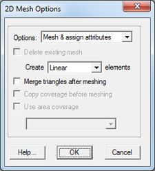
The Map → 2D Mesh command is used to create a 2D mesh using the feature objects in a 2D Mesh coverage. When the Map → 2D Mesh command is selected, the 2D Mesh Options dialog opens. A meshing polygon must have been defined prior to issuing this command. The attributes of the meshing polygon(s) are used to generate the 2D mesh.
The 2D Mesh Options dialog is used to set options for the 2D mesh generation process. The options include:
- Delete existing mesh – If checked, the existing mesh will be deleted. If not checked, the new mesh will merge with the existing mesh
- Merge triangles after meshing – If checked, triangular elements created during the mesh generation process will be merged into quadrilateral elements where possible.
- Copy coverage before meshing – Create a copy of the coverage before the mesh generation algorithm redistributes vertices along the feature arcs defining meshing polygons. Feature arcs are only redistributed when using the scalar paving density mesh generation method.
- Use area coverage – This option is only available is at least one Area Property coverage exists. These coverages consist of polygons with a material type assigned to each polygon. If this option is checked, the material type specified for the polygon in the source coverage is ignored. Instead, each element is assigned a material type based on the polygon the element centroid lies inside of in the area property coverage.
Related Topics
SMS – Surface-water Modeling System | ||
|---|---|---|
| Modules: | 1D Grid • Cartesian Grid • Curvilinear Grid • GIS • Map • Mesh • Particle • Quadtree • Raster • Scatter • UGrid |  |
| General Models: | 3D Structure • FVCOM • Generic • PTM | |
| Coastal Models: | ADCIRC • BOUSS-2D • CGWAVE • CMS-Flow • CMS-Wave • GenCade • STWAVE • WAM | |
| Riverine/Estuarine Models: | AdH • HEC-RAS • HYDRO AS-2D • RMA2 • RMA4 • SRH-2D • TUFLOW • TUFLOW FV | |
| Aquaveo • SMS Tutorials • SMS Workflows | ||
