AHGW:What's New in AHGW 3.1.0: Difference between revisions
(Created page with "The more significant new features in Arc Hydro Groundwater 3.1.0 are listed below. ==General== ===Hardware Locks=== Added faster checking of AHGW licenses when using a har...") |
m (Jmonson moved page Test:What's New in AHGW 3.1.0 to AHGW:What's New in AHGW 3.1.0 without leaving a redirect) |
Latest revision as of 21:29, 12 September 2019
The more significant new features in Arc Hydro Groundwater 3.1.0 are listed below.
General
Hardware Locks
Added faster checking of AHGW licenses when using a hardware lock.
AHGW Learning Center
Updated and added new tutorials on the AHGW Learning Center to reflect some of the new tools in this version.
Groundwater Analyst
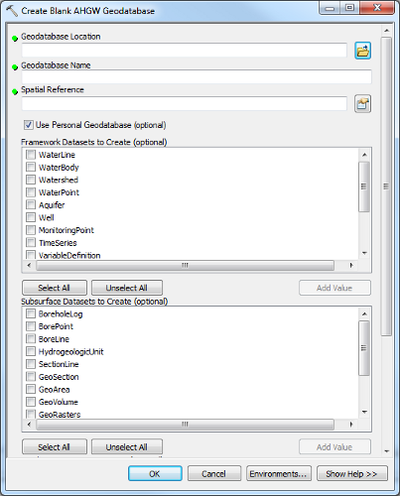
Create Blank AHGW Geodatabase
Added additional feature classes and tables found in the book, "Arc Hydro Groundwater: GIS for Hydrogeology", now available from ESRI Press at Amazon.
Added options to specify which tables and feature classes to create.
Text Import Wizard
Added the comma delimeter to the default options turned on for ".txt" files.
Make Time Series Statistics
Fixed problems when dealing with input features with Z enabled geometry.
Assign HydroID GW
Updated tool to work on tables, in addition to feature classes like before.
Create AHGW Raster Catalog
Added a new tool, which creates a blank Arc Hydro Groundwater raster catalog, either for GeoRasters or RasterSeries.
MODFLOW Analyst
MODFLOW 2005
Arc Hydro Groundwater now supports MODFLOW 2005. A special version of the MODFLOW 2005 executable compatible with Arc Hydro Groundwater has been added. To specify that you are using MODFLOW 2005, specify "MODFLOW 2005" in the "MODFLOW_Version" attribute of the MDFGlobals table. This will automatically be handled if you use the mf2k5_ahgw.exe executable when running any of the MODFLOW Analyst tools that need a MODFLOW executable when running, such as the Import MODFLOW Tables, Run MODFLOW, or Import Georeference MODFLOW Model tools.
In the AHGW installation area, in the MF2K folder, you'll find two executables for MODFLOW 2000 and 2005:
- mf2k_ahgw.exe - for MODFLOW 2000 and AHGW
- mf2k5_ahgw.exe - for MODFLOW 2005 and AHGW
MODFLOW Data Model
The MODFLOW Data Model has been expanded to support additional MODFLOW packages. These include HUF, LAK, STR, SFR, GAG, DRT, ETS and UZF.
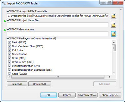
Import MODFLOW Tables
Added parameter to specify packages to overwrite when importing to an existing geodatabase. This allows you to import data to an existing MODFLOW geodatabase by changing one or more tables while leaving the rest of the changes to the database in place. This might be used for example, to just update the WEL table by importing an adjusted well package file into the geodatabase to see the effects of a candidate well.
Points to MODFLOW
Changed behavior of overwrite option to only overwrite instances with the same ID being processed.
Lines to MODFLOW
Changed behavior of overwrite option to only overwrite instances with the same ID being processed.
Polygons to MODFLOW
Changed behavior of overwrite option to only overwrite instances with the same ID being processed.
Export Package EVT
Added additional messages during execution, showing the progress. Helpful for large simulations.
Export Package RCH
Added additional messages during execution, showing the progress. Helpful for large simulations.
Export OBS files tools
Renamed tools to a common format, such as Export OBS CHOB File and EXPORT OBS HOB File.
Updated to be compatible with MODFLOW 2000 and 2005, based on the "MODFLOW_Version" attribute in the MDFGlobals table.
Export OBS DTOB File
Added tool to export the MODFLOW Drain Return Observation Package (DTOB).
Export OBS STOB File
Added tool to export the MODFLOW Stream Observation Package (STOB).
Export Package GAGE
Added tool to export the MODFLOW Stream Gaging (Monitoring) Station File (GAGE).
Export Package UZF
Added tool to export the MODFLOW Unsaturated-Zone Flow Package (UZF).
Export Package DRT
Added tool to export the MODFLOW Drain Return Package (DRT).
Export Package ETS
Added tool to export the MODFLOW Evapotranspiration Segments Package (ETS).
Export Package STR
Added tool to export the MODFLOW Stream Package (STR).
Export Package SFR
Added tool to export the MODFLOW Streamflow-Routing Package (SFR).
Export Package HUF
Added tool to export the MODFLOW Hydrogeologic Unit Flow Package (HUF).
Export Package LAK
Added tool to export the MODFLOW Lake Package (LAK).
Create Well Feature
Fixed problems when dealing with input features with Z enabled geometry.
Subsurface Analyst
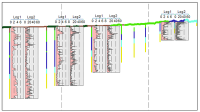
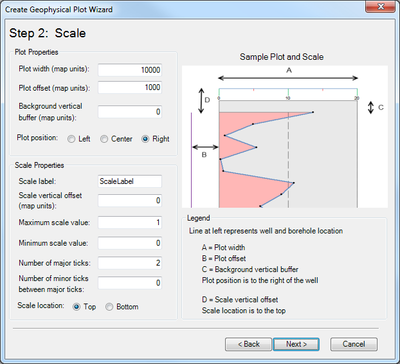
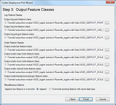
Create XS2D Geophysical Plot Features
Added a new tool for adding geophysical plots to XS2D cross sections. The tool creates features representing geophysical data, such as points, lines and polygon plots, along with scale bars, for use in an XS2D data frame.
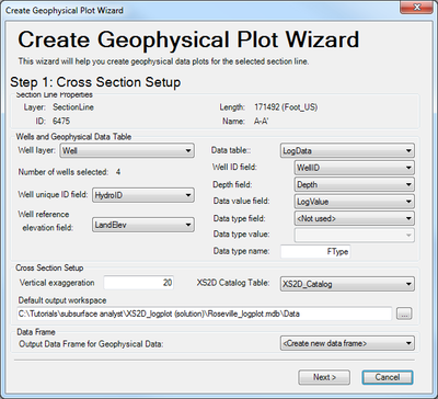
XS2D Log Wizard
A new wizard for easily creating geophysical plot features for a particualr XS2D cross section, allowing for help and guidance for setting up the placement and sizing of the plot features.
Borehole Data to Borepoints
Creates new points from the BoreholeLog table. The points can used for further analysis, such as generating a set of points for a particular HorizonID value.
Desurvey Borelog
Added an optional parameter for Log Table Fields of Interest, which copies fields and attributes from the Log table to the Desurvey table when used.
Rasters to GeoVolumes
Fixed problems when using rasters of different sizes.
Rasters to GeoSections
Fixed problems when using rasters of different sizes.
Create GeoSection Feature Class
Added additional messages during tool execution.
Create GeoVolume Feature Class
Added additional messages during tool execution.
Scale Features
Removed this tool, replaced by the Scale XS2D Features tool.
Scale XS2D Features
Added tool to scale all XS2D features associated with a specified SectionLine to a new vertical exaggeration. This might include feature classes such as XS2D panels, scale lines, panel dividers, and other XS2D feature classes.
Create Bore Lines
Added a fix when dealing with null values in the top and/or bottom elevation fields.
2D Cross Section Wizard
Added an error message if a SectionLine feature with a null HydroID value is chosen.
Updated wizard to allow you to specify the Well unique ID (HydroID) and BoreholeLog WellID fields.
Import XS2D Image Wizard
Added an error message if a SectionLine feature with a null HydroID value is chosen.
Create XS2D Borelines
Added optional parameters to specify the UniqueID and WellID fields if the default naming convention is not used.
Create XS2D Line Feature Class
Fixed an error with invalid prefixes in the name of the new feature class.
Create XS2D Polygon Feature Class
Fixed an error with invalid prefixes in the name of the new feature class.
Transform XS2D Panel to GeoSection
Fixed a problem with invalid XS2D Panel geometry used to create GeoSection features.
Borehole Editor
Changed so that it remembers changes you've made in the current session.
Batching Subsurface Analyst tools
Fixed an error with batching various Subsurface Analyst tools in ArcGIS 10. Sometimes, when setting up batch for a tool with more than one row, you could only edit some of the parameters on the first row, but not for the additional rows.
Transform XS2D Well Detail Line
Tool changed to add an optional data type filter on the Construction table. This gives the option to filter on the well construction table when running the tool.
Transform XS2D Well Detail Polygon
Tool changed to add an optional data type filter on the Construction table. This gives the option to filter on the well construction table when running the tool.
BoreholeLog Table to Points
Fixed an error when a Z-enabled Well input was used when creating output that isn't Z-enabled.
Fixed an error with copying fields, when the same field names existed in the Well input features and BoreholeLog table.
See also
