AHGW:Groundwater Analyst: Difference between revisions
From XMS Wiki
Jump to navigationJump to search
No edit summary |
No edit summary |
||
| Line 1: | Line 1: | ||
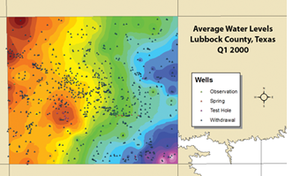
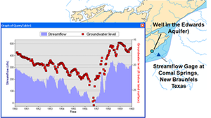
[[File:AHGW Groundwater Analyst example.png|thumb|right|An example of using the groundwater analyst]] | [[File:AHGW Groundwater Analyst example.png|thumb|right|An example of using the groundwater analyst]] | ||
Tools in the Groundwater Analyst allows importing of data into an [[AHGW:AHGW|Arc Hydro Groundwater]] (AHGW) data model, managing key attributes, and visualizing the data. Groundwater Analyst facilitates importing a variety of datasets (wells, time series, cross sections, volumes) into a geodatabase, managing symbology of layers in ArcMap and ArcScene, map and plot time series, and create common products such as water level, water quality, and flow direction maps. | Tools in the Groundwater Analyst allows importing of data into an [[AHGW:AHGW|Arc Hydro Groundwater]] (AHGW) data model, managing key attributes, and visualizing the data. Groundwater Analyst facilitates importing a variety of datasets (wells, time series, cross sections, volumes) into a geodatabase, managing symbology of layers in ArcMap and ArcScene, map and plot time series, and create common products such as water level, water quality, and flow direction maps. | ||
*[[AHGW:Add to Raster Series|Add to Raster Series]] | |||
*[[AHGW:Assign Related Identifier|Assign Related Identifier]] | |||
*[[AHGW:Definition Query Filter|Definition Query Filter]] | |||
*[[AHGW:Flow Direction Map Generator|Flow Direction Map Generator]] | |||
*[[AHGW:HydroID Manager|HydroID Manager]] | |||
*[[AHGW:Time Series Grapher Setup|Time Series Grapher Setup]] | |||
*[[AHGW:Make Time Series Statistics|Make Time Series Statistics]] | |||
*[[AHGW:File Import Wizard|File Import Wizard]] | |||
==Managing Well Data== | ==Managing Well Data== | ||
Revision as of 22:02, 22 August 2019
Tools in the Groundwater Analyst allows importing of data into an Arc Hydro Groundwater (AHGW) data model, managing key attributes, and visualizing the data. Groundwater Analyst facilitates importing a variety of datasets (wells, time series, cross sections, volumes) into a geodatabase, managing symbology of layers in ArcMap and ArcScene, map and plot time series, and create common products such as water level, water quality, and flow direction maps.
- Add to Raster Series
- Assign Related Identifier
- Definition Query Filter
- Flow Direction Map Generator
- HydroID Manager
- Time Series Grapher Setup
- Make Time Series Statistics
- File Import Wizard
Managing Well Data
Some of the features to help with well management include:
- Using a text import wizard
- Creating maps to visualize well data using raster data sets
- Displaying flow vectors using the flow direction generator
- Creating maps to communicate various types of data
Performing Time Series Statistics
Time series statistics can be generated that:
- Show average readings
- Show readings from a range of time
- Query time series data to generate maps
- Use the built-in spatial analyst tools to create raster /images


