SMS:Quadtree Menus: Difference between revisions
| Line 10: | Line 10: | ||
The Quadtree Module ''Data'' menu commands include: | The Quadtree Module ''Data'' menu commands include: | ||
* [[SMS:Dataset Toolbox|'''Dataset Toolbox''']] | * [[SMS:Dataset Toolbox|'''Dataset Toolbox''']] | ||
* [[SMS:Dataset Calculator VTK|'''VTK Data Calculator''']] | <!--* [[SMS:Dataset Calculator VTK|'''VTK Data Calculator''']]--> | ||
* [[SMS:Animations|'''Film Loop''']] | * [[SMS:Animations|'''Film Loop''']] | ||
* [[SMS:Data Transform|'''Transform''']] | * [[SMS:Data Transform|'''Transform''']] | ||
| Line 16: | Line 16: | ||
* '''Set Contour Min/Max''' – This command sets the contour options based on the current options and the selected nodes/vertices or zoom level. | * '''Set Contour Min/Max''' – This command sets the contour options based on the current options and the selected nodes/vertices or zoom level. | ||
* '''Contour Range Options''' – This allows controlling if the '''Set Contour Min/Max''' command applies to dataset specific contour options or the general contour options (for the mesh or scatter modules). It also sets the flags for precision and fill above and below. | * '''Contour Range Options''' – This allows controlling if the '''Set Contour Min/Max''' command applies to dataset specific contour options or the general contour options (for the mesh or scatter modules). It also sets the flags for precision and fill above and below. | ||
* '''Map Elevation''' – Allows selecting which dataset will be used as the elevation set for the quadtree. | |||
===Cells Menu=== | ===Cells Menu=== | ||
Revision as of 19:33, 22 March 2022
The following menus are available in the Quadtree module:
Standard Menus
See SMS Menus for more information.
Module Specific Menus
In addition to the standard menus, the Quadtree module has the Data menu and the Cells menu.
Quadtree Module Data Menu
The Quadtree Module Data menu commands include:
- Dataset Toolbox
- Film Loop
- Transform
- Zonal Classification
- Set Contour Min/Max – This command sets the contour options based on the current options and the selected nodes/vertices or zoom level.
- Contour Range Options – This allows controlling if the Set Contour Min/Max command applies to dataset specific contour options or the general contour options (for the mesh or scatter modules). It also sets the flags for precision and fill above and below.
- Map Elevation – Allows selecting which dataset will be used as the elevation set for the quadtree.
Cells Menu
The Quadtree module Cells menu commands include:
- Split Cells – Subdivides a cell into four subcells.
- Merge Cells – Merges a group of four subcells back into a single cell.
Project Explorer
The following Project Explorer mouse right-click menus are available when the mouse right-click is performed on a Quadtree item.
Quadtree Module Root Folder Right-Click Menus
Right-clicking on the Quadtree module root folder ![]() in the Project Explorer invokes an options menu with the following options:
in the Project Explorer invokes an options menu with the following options:
Quadtree Item Right-Click Menus
Right-clicking on a Quadtree ![]() item in the Project Explorer invokes an options menu with the following module specific options:
item in the Project Explorer invokes an options menu with the following module specific options:
- Delete – Removes the selected quadtree dataset from the project.
- Duplicate – Creates a copy of the selected quadtree dataset.
- Rename – Allows changing the selected quadtree dataset.
- Interpolate to – Brings up the Interpolation Options dialog for the Quadtree Module.
- Convert to
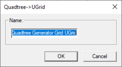
- Quadtree → UGrid – Creates a new UGrid using the Quadtree dataset. A dialog will appear to give a name to the new UGrid. After giving the new UGrid a name and clicking OK, the new VTK Mesh will appear in the Project Explorer.
- Projection – Opens the Object Projection dialog.
- Metadata – Brings up the Metadata dialog.
- Zoom to Quadtree – Will frame the quadtree in the Graphic Window.
- Smooth – Opens the Quadtree Smoothing Options dialog.
Quadtree Tool Menus
Some tools in the Quadtree module have menus that can be accessed by right-clicking while using the tool. See Quadtree Tools for more information.
Related Topics
SMS Menu Bars | |
|---|---|
| Standard Menus: | File • Edit • Display • Window • Help |
| Module Menus: | 2D Mesh • Cartesian Grid • Curvilinear Grid • GIS • Map • Particle • Quadtree • Raster • Scatter |
| Model Menus: | ADCIRC • BOUSS-2D • CGWAVE • CMS-Flow • CMS-Wave • FESWMS • Generic Model • GenCade • PTM • RMA2 • RMA4 • SRH-2D • STWAVE • TUFLOW |
SMS – Surface-water Modeling System | ||
|---|---|---|
| Modules: | 1D Grid • Cartesian Grid • Curvilinear Grid • GIS • Map • Mesh • Particle • Quadtree • Raster • Scatter • UGrid |  |
| General Models: | 3D Structure • FVCOM • Generic • PTM | |
| Coastal Models: | ADCIRC • BOUSS-2D • CGWAVE • CMS-Flow • CMS-Wave • GenCade • STWAVE • WAM | |
| Riverine/Estuarine Models: | AdH • HEC-RAS • HYDRO AS-2D • RMA2 • RMA4 • SRH-2D • TUFLOW • TUFLOW FV | |
| Aquaveo • SMS Tutorials • SMS Workflows | ||
