GMS:UGrid Interpolation: Difference between revisions
From XMS Wiki
Jump to navigationJump to search
No edit summary |
No edit summary |
||
| Line 4: | Line 4: | ||
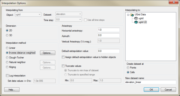
[[File:UGridInterpolation.png|thumb|600px|none]] | [[File:UGridInterpolation.png|thumb|600px|none]] | ||
This dialog allows selecting the interpolation options to use, and the UGrid to interpolate to. See [[GMS:Interpolation|Interpolation]] for more information on interpolation. | This dialog allows selecting the interpolation options to use, and the UGrid to interpolate to. See [[GMS:Interpolation|Interpolation]] for more information on interpolation. Options include: | ||
*''Interpolating from'' | |||
**''Object'' | |||
**''Dataset'' | |||
**''Time step'' | |||
**''Use all time steps'' | |||
*''Interpolating to'' | |||
*''Dimension'' | |||
**''2D'' | |||
**''3D'' | |||
*''Anisotropy'' | |||
**''Horizontal anisotropy'' | |||
**''Azimuth'' | |||
**''Vertical Anisotropy (1/z mag)'' | |||
*''Interpolation method'' | |||
**''Linear'' | |||
**''Inverse distance weighted'' | |||
**''Clough-Tocher'' | |||
**''Natural neighbor'' | |||
**''Kriging'' | |||
**''Log interpolation'' | |||
**''Set data value <=0 to'' | |||
*''Default extrapolation value'' | |||
*''Assign default extrapolation value to hidden objects'' | |||
*''Truncate values'' | |||
**''Truncate to min/max of dataset'' | |||
**''Truncate to specified range'' | |||
**''Min'' | |||
**''Max'' | |||
*'"Create dataset at'' | |||
**''Points'' | |||
**''Celss'' | |||
*''New dataset name'' | |||
It is also possible to drag a UGrid dataset and drop it on to another UGrid to open this dialog and indicate what the interpolation target is. | It is also possible to drag a UGrid dataset and drop it on to another UGrid to open this dialog and indicate what the interpolation target is. | ||

