SMS:TABS Attribute Dialog: Difference between revisions
From XMS Wiki
Jump to navigationJump to search
| Line 6: | Line 6: | ||
* Refine point (checked = on) | * Refine point (checked = on) | ||
** Element Size – Specify the nodal spacing, or element edge length in the vicinity of the refine point. Refine points are only used if the mesh is generated using the [[SMS:Paving|Paving]] or [[SMS:Paving#Scalar Paving Density|Scalar Paving Density]] mesh generation methods. | |||
* Element Size – Specify the nodal spacing, or element edge length in the vicinity of the refine point. Refine points are only used if the mesh is generated using the [[SMS:Paving|Paving]] or [[SMS:Paving#Scalar Paving Density|Scalar Paving Density]] mesh generation methods. | |||
* Assign 1-D Geometry – Opens the ''GWN Card Definition'' dialog | * Assign 1-D Geometry – Opens the ''GWN Card Definition'' dialog | ||
:[[Image:Assign 1D Geometry.jpg|thumb|none|left|350 px|''GWN Card Definition'' dialog]] | |||
==TABS Arc Attributes Dialog== | ==TABS Arc Attributes Dialog== | ||
Revision as of 16:52, 26 July 2017
TABS models have attribute dialogs for both points and arcs.
TABS Point Attributes Dialog
File:TABS Feature Point.jpg
TABS Feature Point/Node Options dialog
The TABS Feature Point/Node Options dialog is used to set the attributes for a feature point / refine point represented by a feature point in a 2D Mesh model coverage. Attributes that can be specified for each feature point / refine point include:
- Refine point (checked = on)
- Element Size – Specify the nodal spacing, or element edge length in the vicinity of the refine point. Refine points are only used if the mesh is generated using the Paving or Scalar Paving Density mesh generation methods.
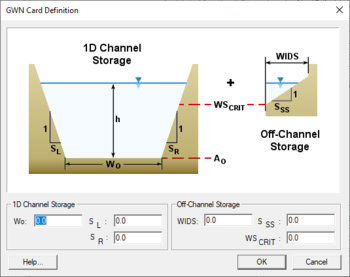
- Assign 1-D Geometry – Opens the GWN Card Definition dialog
TABS Arc Attributes Dialog
File:TABS Arc Attributes.jpg
TABS Feature Arc Attributes dialog
The TABS Feature Arc Attributes dialog is used to set the attributes for feature arcs. Attributes that can be specified for each feature arc include:
- Arc Type
- None'
- Boundary Conditions – Options button opens the RMA2 Nodestring Boundary Conditions dialog
- Continuity Check/Flux
Related Topics
SMS – Surface-water Modeling System | ||
|---|---|---|
| Modules: | 1D Grid • Cartesian Grid • Curvilinear Grid • GIS • Map • Mesh • Particle • Quadtree • Raster • Scatter • UGrid |  |
| General Models: | 3D Structure • FVCOM • Generic • PTM | |
| Coastal Models: | ADCIRC • BOUSS-2D • CGWAVE • CMS-Flow • CMS-Wave • GenCade • STWAVE • WAM | |
| Riverine/Estuarine Models: | AdH • HEC-RAS • HYDRO AS-2D • RMA2 • RMA4 • SRH-2D • TUFLOW • TUFLOW FV | |
| Aquaveo • SMS Tutorials • SMS Workflows | ||
