GMS:Solid Module: Difference between revisions
From XMS Wiki
Jump to navigationJump to search
No edit summary |
(No difference)
|
Revision as of 17:59, 23 June 2011
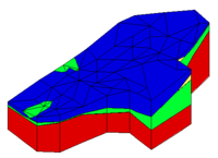
Solids are used for site characterization and visualization. Solids can also be used to define layer elevation data for MODFLOW models using the Solids -> MODFLOW command or Solids to HUF and to define a layered 3D mesh using the Solids -> Layered Mesh.
GMS – Groundwater Modeling System | ||
|---|---|---|
| Modules: | 2D Grid • 2D Mesh • 2D Scatter Point • 3D Grid • 3D Mesh • 3D Scatter Point • Boreholes • GIS • Map • Solid • TINs • UGrids | |
| Models: | FEFLOW • FEMWATER • HydroGeoSphere • MODAEM • MODFLOW • MODPATH • mod-PATH3DU • MT3DMS • MT3D-USGS • PEST • PHT3D • RT3D • SEAM3D • SEAWAT • SEEP2D • T-PROGS • ZONEBUDGET | |
| Aquaveo | ||
