GMS:Redistribute Grid Cells
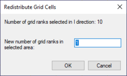
The number of 3D grid rows, columns or layers can be changed via the Redistribute Grid Cells dialog. This dialog is accessed by selecting rows, columns or layers using the Select i, Select j or Select k tools, right-clicking and clicking the Redistribute menu command.
The Redistribute Grid Cells dialog indicates the number of ranks that are selected—rows, columns, or layers depending on the tool used for the selection. It also allows entering a new number for the rank. Entering a new number will cause GMS to increase or decrease the number of ranks.
The new ranks are distributed evenly in the selected area and any model boundary conditions are positioned as close to their old locations as possible. Modifications may be necessary depending on the project needs. Ways to alter grid rows, columns and layers include:
- Grid ranks can be inserted manually using the Add i Boundary, Add j Boundary and Add k Boundary tools.
- Grid ranks can be merged manually using the Select i, Select j or Select k tools, right-clicking and selecting the Merge command.
- Redistribute Layers dialog accessed through the Grid menu.
| GMS – Groundwater Modeling System | ||
|---|---|---|
| Modules: | 2D Grid • 2D Mesh • 2D Scatter Point • 3D Grid • 3D Mesh • 3D Scatter Point • Boreholes • GIS • Map • Solid • TINs • UGrids | |
| Models: | FEFLOW • FEMWATER • HydroGeoSphere • MODAEM • MODFLOW • MODPATH • mod-PATH3DU • MT3DMS • MT3D-USGS • PEST • PHT3D • RT3D • SEAM3D • SEAWAT • SEEP2D • T-PROGS • ZONEBUDGET | |
| Aquaveo | ||

