GMS:Redistribute Layers
From XMS Wiki
Jump to navigationJump to search
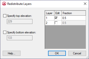
One way to alter 3D grid layer thicknesses is via the Redistribute Layers dialog accessed via the Grid | Redistribute Layers menu command. This dialog has two sections: one section to specify grid top and bottom elevation and another section to specify layer thickness.
The dialog can specify grid elevation with the following options:
- Specify top elevation – Designates a constant top elevation for the grid.
- Specify bottom elevation – Designates a constant bottom elevation for the grid.
If not specified, GMS will evenly distribute the layer thickness to match the new elevation values, increasing or decreasing the thickness of all layers.
The layer thickness table lists all available layers and allows editing the relative thicknesses of each grid layer. It has the following options.
- Edit – Option must be checked to change the thickness of the layer. GMS requires that at least one layer not be selected as the thickness for this layer will automatically be calculated. If multiple layers are left unselected, GMS will even distribute the remaining layer thickness between the unselected layers.
- Fraction – Changes the thickness of the layer by the percentage value entered. The value needs to be a positive value between 0.01 and 0.99. GMS will automatically adjusts the fraction value of other layers so the total equals 1 (100%).
Other ways to alter grid layer thicknesses:
- Dragging layer nodes with the Select Node tool.
- Using Redistribute Grid Cells dialog to change the number of layers.
| GMS – Groundwater Modeling System | ||
|---|---|---|
| Modules: | 2D Grid • 2D Mesh • 2D Scatter Point • 3D Grid • 3D Mesh • 3D Scatter Point • Boreholes • GIS • Map • Solid • TINs • UGrids | |
| Models: | FEFLOW • FEMWATER • HydroGeoSphere • MODAEM • MODFLOW • MODPATH • mod-PATH3DU • MT3DMS • MT3D-USGS • PEST • PHT3D • RT3D • SEAM3D • SEAWAT • SEEP2D • T-PROGS • ZONEBUDGET | |
| Aquaveo | ||

