User:Rcorrigan/AHGW Pro:Create XS2D Boreline Feature Class
From XMS Wiki
Jump to navigationJump to search
The Create XS2D Boreline Feature Class tool is accessed by double-clicking on "![]() Create XS2D Boreline Feature Class" under the "
Create XS2D Boreline Feature Class" under the "![]() XS2D Editor" toolset under the "
XS2D Editor" toolset under the "![]() Subsurface Analyst" toolset under the "
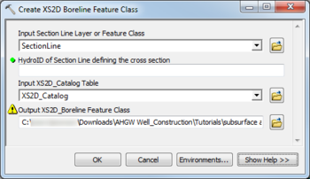
Subsurface Analyst" toolset under the "![]() ArcHydroGroundwater.pyt" toolbox. This tool creates a feature class to store 2D cross section borelines. These vertical lines show well locations and stratigraphy in the wells. This function only creates the feature class. Separate functions are used to populate the feature class.
ArcHydroGroundwater.pyt" toolbox. This tool creates a feature class to store 2D cross section borelines. These vertical lines show well locations and stratigraphy in the wells. This function only creates the feature class. Separate functions are used to populate the feature class.
- ArcGIS Notes – In older versions of ArcGIS, this tool is accessed through the "Arc Hydro Groundwater Tools" toolbox. It appears as a dialog, not a pane.
- The icons vary between ArcGIS and ArcGIS Pro.
- The names of the fields in this tool might be different in ArcGIS.
The following fields are available. Required fields are marked with a ![]() icon. In ArcGIS, they are marked with a
icon. In ArcGIS, they are marked with a ![]() icon. Fields marked with a
icon. Fields marked with a ![]() icon may either not be supported or the table doesn't exist.
icon may either not be supported or the table doesn't exist.
 Input Section Line Layer or Feature Class – Click the
  button to bring up the Input Section Line Layer or Feature Class dialog in order to specify the layer or feature class containing the section line defining the cross section for which features are to be created.
 HydroID of Section Line defining the cross section – Enter the numerical ID uniquely identifying the section line feature defining the cross section.
 Input XS2D_Catalog Table – Click the
  button to bring up the Input XS2D_Catalog Table dialog in order to specify the table storing a catalog of feature classes participating in 2D cross sections.
 Output XS2D_Boreline Feature Class – Click the
  button to bring up the Output XS2D_Boreline Feature Class dialog in order to specify the empty Boreline feature class created by this tool.

