GMS:Solid Module
From XMS Wiki
Jump to navigationJump to search
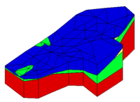
Solids are used for site characterization and visualization. Solids can also be used to define layer elevation data for MODFLOW models using the Solids -> MODFLOW command or Solids to HUF and to define a layered 3D mesh using the Solids -> Layered Mesh.
GMS – Groundwater Modeling System | ||
|---|---|---|
| Modules: | 2D Grid • 2D Mesh • 2D Scatter Point • 3D Grid • 3D Mesh • 3D Scatter Point • Boreholes • GIS • Map • Solid • TINs • UGrids | |
| Models: | FEFLOW • FEMWATER • HydroGeoSphere • MODAEM • MODFLOW • MODPATH • mod-PATH3DU • MT3DMS • MT3D-USGS • PEST • PHT3D • RT3D • SEAM3D • SEAWAT • SEEP2D • T-PROGS • ZONEBUDGET | |
| Aquaveo | ||
