GMS:Converting Borehole Data
From XMS Wiki
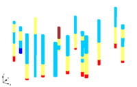
Borehole data can be converted to other types of objects with in GMS such as 2D Scatter Points, TINs, 3D Meshes. Borehole data is converted by using the following commands in the Boreholes menu:
- Horizons to Solids
- Horizons to HUF
- Horizons to 3D Mesh
- Contacts to TIN
- The Contacts → TIN command is used to create a TIN surface from a set of selected contacts.
- Contacts to 2D Scatter Points
- A set of selected contacts can be converted to a 2D scatter point set using the Contacts → 2D Scatter Points command.
- Sample Data to 3D Scatter Points
- The Sample Data → 3D Scatter Points command brings up the Sample Data → Scatter Points dialog that is used to create a 3D scatter point set from sample data.
- Sample Data to Stratigraphy
- Watertable to 2D Scatter Points
- The water table coordinates for a set of boreholes can be converted to a 2D scatter point set using the Water Table → 2D Scatter Points command.
- Add Contacts to TIN
- The Add Contacts to TIN command is used to enter a point from a contact into the active TIN. The contact(s) are first selected and the command is then chosen from the Borehole menu. Typically all contacts which should be part of a TIN are selected before generating the TIN, but sometimes one is inadvertently left out, or more boreholes are added later.
| GMS – Groundwater Modeling System | ||
|---|---|---|
| Modules: | 2D Grid • 2D Mesh • 2D Scatter Point • 3D Grid • 3D Mesh • 3D Scatter Point • Boreholes • GIS • Map • Solid • TINs • UGrids | |
| Models: | FEFLOW • FEMWATER • HydroGeoSphere • MODAEM • MODFLOW • MODPATH • mod-PATH3DU • MT3DMS • MT3D-USGS • PEST • PHT3D • RT3D • SEAM3D • SEAWAT • SEEP2D • T-PROGS • ZONEBUDGET | |
| Aquaveo | ||
