GMS:Redistribute Layers
From XMS Wiki
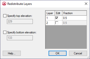
One way to alter 3D grid layer thicknesses is via the Redistribute Layers dialog accessed via the Grid | Redistribute Layers menu command. This dialog has two sections: one section to specify grid top and bottom elevation and another section to specify layer thickness.
The dialog can specify grid elevation with the following options:
- Specify top elevation – Designates a constant top elevation for the grid.
- Specify bottom elevation – Designates a constant bottom elevation for the grid.
The layer thickness table lists all available layers and allows editing the relative thicknesses of each grid layer. It has the following options.
- Edit – Option must be checked to change the thickness of the layer.
- Fraction – Changes the thickness of the layer by the percentage value entered.
Other ways to alter grid layer thicknesses:
- Dragging layer nodes with the Select Node tool.
- Using Redistribute Grid Cells popup menu command.
| GMS – Groundwater Modeling System | ||
|---|---|---|
| Modules: | 2D Grid • 2D Mesh • 2D Scatter Point • 3D Grid • 3D Mesh • 3D Scatter Point • Boreholes • GIS • Map • Solid • TINs • UGrids | |
| Models: | FEFLOW • FEMWATER • HydroGeoSphere • MODAEM • MODFLOW • MODPATH • mod-PATH3DU • MT3DMS • MT3D-USGS • PEST • PHT3D • RT3D • SEAM3D • SEAWAT • SEEP2D • T-PROGS • ZONEBUDGET | |
| Aquaveo | ||
This article is a [stub]. You can help xmswiki by expanding it.

