AHGW:Transform GeoSection to XS2D Panel
From XMS Wiki
Jump to navigationJump to search
The Transform GeoSection to XS2D Panel tool is accessed by double-clicking on "![]() Transform GeoSection to XS2D Panel" under the "
Transform GeoSection to XS2D Panel" under the "![]() XS2D Editor" toolset under the "
XS2D Editor" toolset under the "![]() Subsurface Analyst" toolset under the "
Subsurface Analyst" toolset under the "![]() Arc Hydro Groundwater Tools" toolbox. This tool creates XS2D_CrossSection features (2D Polygons) from GeoSection (Multipatches) and SectionLine features.
Arc Hydro Groundwater Tools" toolbox. This tool creates XS2D_CrossSection features (2D Polygons) from GeoSection (Multipatches) and SectionLine features.
The following fields are available. Required fields are marked with a ![]() icon. Fields marked with a
icon. Fields marked with a ![]() icon may either not be supported or the table doesn't exist.
icon may either not be supported or the table doesn't exist.
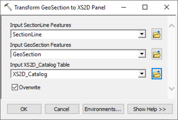
- Input SectionLine Features – Click the
 button to bring up the Input Section Line Layer or Feature Class dialog in order to specify the input line features representing section lines.
 - Input GeoSection Features – Click the
 button to bring up the Input Section Line Layer or Feature Class dialog in order to specify the input multipatch features representing 3D sections.
 - Input XS2D_Catalog Table – Click the
 button to bring up the Input XS2D_Catalog Table dialog in order to specify the XS2D_Catalog table as defined by the Arc Hydro Groundwater Data Model. This table stores information about the XS2D_Panel feature classes used to create XS2D_Panel features.
 - Overwrite – Optional. Turn on to clear the target feature class prior to creating new XS2D_CrossSections. Turn off to append new XS2D_CrossSections to the existing feature class.

